GEOGRAPHY GEOGRAPHY |
| 1. Serbia: The Cross-road of Europe |
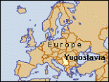
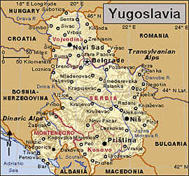
Serbia covers about 34,116 square miles (88,361 square kilometres) in south-eastern Europe bordering the Republic of Montenegro, Bosnia and Herzegovina, Croatia, Hungary, Romania, Bulgaria, Macedonia and Albania.
Serbia is referred to as the cross roads of Europe. The international roads and railways passing down its river valleys make up the shortest link between Western and Central Europe, on one side, and the Middle East, Asia and Africa, on the other. This explains the geopolitical importance of its territory. These roads follow the course of the valley of the river Morava and Vardar to Thessaloniki; the other, the river Nisava up to Sofia and Istanbul.
| 2. Landscapes |
Northern Serbia is mainly flat, while its central and southern areas consist of highlands and mountains. The flatlands are mainly in Vojvodina (the Pannonian Plain and its rim: Macva, the Sava Valley, the Morava Valley, Stig and the Negotin Marches in Eastern Serbia).
55 per cent of Serbia is arable land, and 27 per cent is forested. Of its mountains 15 reach heights of over 2,000 meters, the highest being Djeravica in the Prokletija range (2,656 m).
The terrain of Serbia is extremely varied:
- to the north, rich fertile plains; to the east, limestone ranges and basins;
- to the South-east, ancient mountains and hills;
- to the South-west, extremely high shoreline with no islands off the coast.
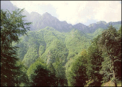
 A) Mountains A) Mountains |
The Pannonian Plains lie in northern Serbia. The region is mostly flat, with some low hills. Still, Serbia is mostly mountainous, being ringed by the Dinaric Alps on the west, the Sar Mountains and the North Albanian Alps (Prokletije) on the south, and the Balkan and Carpathian mountains on the east. Many peaks in these ranges surpass 6,000 feet (1,800 m) in elevation.
If you climb up the Stara Planina, Prokletije, Rudnik, Jastrebac, Golija and Cer mountain you might say you have reached the top of world since all these peaks taken together are higher than Mount Everest. And all you need to climb them is a pair of comfortable shoes.
Nature took great pains to bestow many hills and valleys to this country, to sculpture the mountain chains, to chisel the canyons and the gorges. If art takes after nature, then it is possible, on every slope in Serbia, for art to be jealous of its master.
If you climb up the Stara Planina, Prokletije, Rudnik, Jastrebac, Golija and Cer mountains you might say you have reached the top of world since all these peaks taken together are higher than Mount Everest. And all you need to climb them is a pair of comfortable shoes.
Every walk you take can end with an armload of flowers or herbs and a basket of mushrooms or forest fruits.
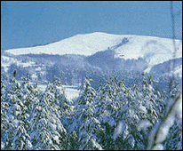
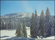
In Kopaonik and Tara: never get time off for resting. In spring and summer, you can enjoy tennis, horseback-riding, swimming, mountain climbing ... If you do your climbing up in summer, do your climbing down in winter … by skis. The 100 square kilometres of verdant Kopaonik turns into a modern and very enjoyable ski centre in winter. Kopaonik is the mountain of contrasts and of all seasons, with monasteries on its slopes, ice-cold water springs at its foot and the sun at its peaks.
Brezovica, a locality on the northern side of the Sara mountain, offers skiing above the clouds, at more than 2,000 meters above sea level. Once the skiers leave Brezovica, the hunting and angling enthusiasts occupy it.
Prokletije, the Alps of the Southern Europe, has the highest, the steepest peaks in Serbia.
Divcibare, a plateau on the Maljen Mountain, is white throughout the year, half a year because of the narcissuses, the other half because of the snow...
On the slopes Zlatibor, a large recreation centre, sports teams practice for strenuous competitions, while the skiers show their skills on the tracks of Tornik. Zlatibor village of Sirogojno, a unique ethnic park in Serbia, famous for its knitters who for generations passed over the tradition of wool spinning and knitting.
| B) Rivers |
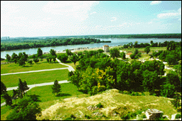
A number of rivers flow through Serbia. They include the Danube, one of Europe's longest waterways. The Danube flows southeast to the Black Sea. The river Morava runs north through the hills of southern and central Serbia and then empties into the Danube.
Serbian rivers belong to the basins of the Black, Adriatic and Aegean Seas. Three of them, the Danube, Sava and Tisa, are navigable. The longest river is the Danube, which flows for 588 of its 2,857 kilometres course through Serbia. The river Sava flows eastward, emptying into the Danube at Belgrade. The 50,000 km. of waterways in Serbia has adorned the country with its silver tassels.
The river Morava winds through the country offering a lot of fish to fishermen. If, instead of a goldfish, you desire to hook in the real gold, the banks of the river Pek are waiting for you.
There are nice boats crossing the river Tisa and instead sailboats crossing the river Sava.
Every stream, cascade or fountainhead in Serbia ends in a river, and all the rivers in Serbia (save two) in the Danube. The Danube, parts of which in Serbia remind one of a sea, has always linked us with the world. It is not until it reaches Serbia that the Danube becomes the largest navigable river in Europe.
In economical terms, the Danube basin has always been extremely important for the development of the country. With the commissioning of the Rhine-Main-Danube Canal in September 1992, the Black Sea and the Near and Far Eastern ports have come much nearer to Europe. Serbia is linked to the Adriatic Sea and Montenegro via Belgrade-Bar railway. For centuries, the great river has been coming to us and leaving us - and is returning to us in the form of electricity. On its way out from the Djerdap canyon the mighty Danube has been tamed and made to serve one of the largest hydroelectric power plants in Europe.
Man took upon himself the duties of nature and created numerous artificial lakes: the lakes of Djerdap, Vlasina, Bor, Zlatar, Srebrno near Veliko Gradiste.
| 3. Climate |
The climate in Serbia varies greatly. In the north, you will find a continental climate (i.e. cold winter and hot, humid summers with well distributed rainfall); In the centre of Serbia there reigns a continental and Mediterranean climate, whereas to the south, one will find an Adriatic climate along the coast, and hot, dry summers and autumns and relatively cold winters with heavy snowfall inland.
The Pannonian Plains have cold winters with a freezing wind called a kosava. Summers are dry and hot, with temperatures often rising to about 38 °C. In Belgrade, on the edge of the Pannonian Plains, the average January temperature is 0 °C. The average July temperature is 23 °C. The rest of Serbia has bitterly cold winters with much snow. Heavy rains fall in early summer. Summers are warm in the mountain valleys but cool at higher elevations.
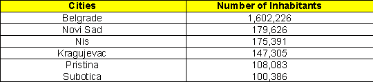
| 4. Cities |
Cities organisation: The territorial order of the Republic of Serbia is regulated by the Law on Territorial Organization and Local Self-Government, adopted in the National Assembly on July 24, 1991. Under the Law, the municipalities, cities and settlements make the bases of the territorial organization.
By its Enactment of 29 January 1992, the Government of the Republic of Serbia defined the state administration affairs that shall be run by the competent Ministries out of their seats, within the districts as regional centres of state authority.
see table
| 5. Districts |
Under the Law, the municipalities, cities and settlements make the bases of the territorial organization. There are 29 districts:
The BACKA NORTH DISTRICT - expands in the north of the Republic. It encompasses the municipalities of: Subotica, Backa Topola and Mali Idjos. It has a population of 205,401. Seat of the District is in the city of Subotica. Subotica is a multi-ethnic and multi-religious center; in addition to the major Catholic and Orthodox, there are other nearly thirty small-size religious communities in the town. The most remarkable church buildings are: the Cathedral of St. Theresa of Avil from 1797, the Franciscan Monastery from 1723, the Orthodox Church from the eighteenth century, the Synagogue and Orthodox Church in Aleksandrovo, from seventeenth century. In this region the food industry is especially well developed: the "29 novemnar" meat industry, "Pionir" Sweets Factory and "Fidelinka" bread and flour products factory. By crops (maize, wheat and sunflower) yields Subotica ranks among the leading one in the country.
The CENTRAL BANAT DISTRICT - expands in the North-Eastern parts of Serbia. It encompasses the municipalities of: Novi Becej, Nova Crnja, Zitiste, Secanj and Zrenjanin. The economy of Zrenjanin is diverse: industry, agriculture, forestry, building industry, and transport. The leading branch is the food-processing industry, integrated under the "Servo Mihalj" Industrial- Agricultural Combine. Other major representatives of the Zrenjanin economy are: the DD "ZIP" brewery, the DD "Luxol" chemical industry and the "Zarko Zrenjanin" furniture factory.
The NORTH BANAT DISTRICT - expands in the northern parts of the Republic. It encompasses the municipalities of: Kanjiza, Senta, Ada, Coka, Novi Knezevac, and Kikinda. It has a population of 179,783. Seat of the District is in the city of Kikinda. In Kikinda was founded the first Serb printing-house, in 1878, to be followed a year later by the opening of the first library. This city is also reputable for its painters, including Teodor Ilic Cesljar (13th cent.), Nikola Aleksic (19th cent.), Djura Pecic (late 19th cent.), and Djura Jaksic, a painter and author. Kikinda was the scene of the first theatrical performance, given in GERMAN, in 1796. Kikinda is the centre of the Yugoslav clay building materials production, as a seat of the IGM DD "Toza Markovic" company, which is the oldest clay producer in Europe. The "Kikinda" foundry is the major Yugoslav producer and exporter of grinders. Also the "25 maj" factory of agricultural machines and equipment, and the "Electron" are the factories running production for both the local and foreign markets.
The SOUTH BANAT DISTRICT - expands in the eastern parts of Serbia. It encompasses the following municipalities: Plandiste, Opovo, Kovacica, Alibunar, Vrsac, Bela Crkva, Pancevo, and Kovin. It has a population of 328,428. Seat of the District is in Pancevo. Pancevo is distinguished for its numerous cultural institutions: the "Veljko Vlahovic" National Library, the Historic Archives, and the Institute for Protection of Culture Monuments. The most remarkable cultural monuments of this region are: The Vojlovica Monastery, built in 1405, the Church of Assumption and the Church of Transfiguration built in 1811 and the National Museum, built in 1833. In this modern, industrial region stand out the "Pancevo" Oil Refinery, the "Azotara" Fertilizers Plants, and the Pancevo PETROCHEMISTRY.
The BACKA SOUTH DISTRICT - expands in the central part of the Pannonian Plain, in the north of Serbia. This district encompasses the municipalities of: Srbobran, Bac, Becej, Vrbas, Backa Palanka, Backi Petrovac, Zabalj, Novi Sad, Titel, Temerin, Beocin, and Sremski Karlovci. It has a population of 553,027. Seat of the District is Novi Sad, the biggest city in the Serbia's Autonomous Province of Vojvodina. Novi Sad has roofed the first Serb elementary school (1703), the first Serb Grammar School (1871), a number of museums and galleries among which the most famous are the Museum of Vojvodina, and the City Library (1844). Novi Sad is the residence of the oldest cultural-scientific Institution of the Serb People: the Mariachi Srpska, founded in 1862, as well as of the Serb National Theatre (1861). Within the District the following industries prevail: chemical, oil, machines, tools and electrical porcelain, textile, food, and building industry.
The SREMSKI DISTRICT - expands in the western parts of the Republic. It encompasses the municipalities of: Sid, Indjija, Sremska Mitrovica, Irig, Ruma, Stara Pazova, and Pecinci. It has a population of 309,981. Seat of the district is in the city of Sremska Mitrovica. The Monasteries on the mountain Fruska Gora are the greatest cultural treasure of this region. They include the Grgeteg monastery from 1471 and the Jazak monastery from 1522. The Krusedol monastery is a true treasury of the Vojvodian painting. It was founded in 1514 as an endowment of Orthodox bishop Maksim Brankovic and his mother Angelina. In the Novo Hopovo monastery particularly attractive is the church architecture and the fresco paintings. The exact time of its first construction is unknown, but 1765 is known as the year of its reconstruction. Leading actors in the economy of Sremska Mitrovica are the "Matroz" factory of cellulose and paper, the Wood Combine, the "1 November" furniture factory and the "Woods of Serbia".
The MACVANSKI DISTRICT - expands in the western parts of Serbia. It encompasses the municipalities of: Bogatic, Sabac, Loznica, Vladimirci, Koceljeva, Mali Zvornik, Krupanj, and Ljubovija. It has a population of 339,644. Its seat is in the city of Sabac. In the vicinity of Sabac can be seen famous monuments, dedicated to well known events from the history of Serb people: the Monument to Karadjordje and Serb Heroes of the First Serbian Uprising and the Museum of the Battle of Misar, the remnants of the ancient cities on the banks of the Sava river: Novo Selo, the site of the King Milutin's Palace and Kosanin grad, the medieval fortress on the Cer Mountain. Not far away from Loznica stands the village of Trsic, the birth place of the Reformer of Serb language and orthography, Vuk Karadzic. From Trsic, a footway leads to the Tronosa Monastery, one of the oldest medieval endowments of the Nemanjic dynasty. This fourteenth century monastery plaid an important part in the preservation of Serb national culture and tradition. Over a long period, and particularly during the fourteenth century, a copying school tradition was nourished in it, for its own and other monasteries' needs. Thus were preserved the historic and cultural documents of the Serb people. Economy of this region: plants: "Zorka" chemical industry, the "Sapcanka" Food Industry, the "Jela" furniture industry and the "Metaloplastika" metal and plastics industry.
The KOLUBARSKI DISTRICT - occupies the central part of western Serbia. It encompasses the municipalities of: Osecina, Ub, Lajkovac, Valjevo, Mionica, and Ljig. It has a population of 200,560. The seat of the District is in the city of Valjevo, on the banks of the Kolubara river. This region is distinguished for its cultural-historic monuments: the Muslim's Palace, a typical example of the Turkish architecture built in the thirteenth century, the Tower of the Nenadovic Family, built in 1813 by Duke Janko, the church of Valjevo originating from 1838 which is a rare example of monumental classicistic style building in Serbia. Prevailing industries in this region are: metal industry ("Krusik" DD Holding Corporation,": "Gradac" DD Screw Factory), agricultural production (plums, raspberries, blackberries) and food processing industry ("Srbijanka" DD). The major tourism resorts in the district are: the Divcibare Mountains and the Vrujci Spa.
The PODUNAVSKI DISTRICT - expands in the central part of the Republic. It encompasses the municipalities of: Smederevo, Smederevska Palanka, and Velika Plana. It has a population of 226,589. Seat of the District is in the city of Smederevo. Smederevo was the capital of the Serb State in the fourteenth century - there stood the royal palace at the time of the then Serb ruler Djuradj Brankovic. Today, in the remnants of the Smederevo fortress, finished in 1430, traces of the former palace, chapel, and the house of the royal family can be discerned. At the old city cemetery stands a church from the fourteenth century, assumed to have been the family vault of the Serb ruler Djuradj Brankovic, which gave rise to numerous legends. In economic regard, Smederevo is today one of the leading cities in Serbia. Its major companies are the Smederevo Metal-processing Combine, the DP "Zelvoz" working on the technology of passenger, transport and special railroad cars, the "Fagram" holding enterprise producing constructional machines - which, together with the "Tehnogas", "Jugopetrol", and "Lasta" have contributed to making this region a successful and dynamic industrial centre.
The BRANICEVSKI DISTRICT - expands in the north-east of Sebia. It encompasses the municipalities of: Veliko Gradiste, Pozarevac, Golubac, Malo Crnice, Zabari, Petrovac, Kucevo, and Zagubica. It has a population of 253,492. Seat of the District is in the city of Pozarevac, a famous communication cross-road. In the mid-nineteenth century, at the time of the Serb state emancipation, Pozarevac became, along with Kragujevac, the second metropolis of Prince Milos Obrenovic. During his lifetime, Prince Milos Obrenovic had erected monuments to his memory in Pozarevac: the church (in 1819), palace (in 1825), new market-place (in 1827) and stud-farm - Ljubicevo (in 1860). Some of the places of cultural importance in Pozarevac are: the National Museum (the first built after the Belgrade), the Tulba Ethnic Park (a unique out-door museum) and the Gallery of Paintings of Milena Pavlovic-Barili (a distinguished surrealistic artist and poetess). Business facilities of this District are concentrated in the vicinity of the cities of Pozarevac and Costal. The most prominent is the food-industry giant: Agricultural-industrial Combine Pozarevac which provides employment to huge number of men and satisfies one quarter of the overall demands of the Republic of Serbia.
The SUMADIJA DISTRICT - Central part of the Republic. It encompasses the municipalities of: Arandjelovac, Topola, Raca, Kragujevac, Batocina, Knic, and Lapovo. It has a population of 312,160. Seat of the District is in the city of Kragujevac. In the vicinity of Kragujevac stand the medieval monasteries, such as: the Annunciation monastery Divostin from the thirteenth century, the St. Nicholas monastery, believed to have existed at the time of the Kosovo Battle (1389), and the Draca monastery from unknown times. In 1833 the first Serb Grammar School south of the Sava and the Drina rivers was founded in Kragujevac. Over the last fifty years this city of the Serb schooling bears a symbol of grief: in the Memorial Park in Sumarice there a monument to the executed pupils and teachers of this Grammar School. Wanting to give a frightening example to the entire Serbia, German fascists executed in Kragujevac in one day only, on October 21, 1941, 7,000 citizens, and among them about 300 pupils and 18 teachers of the Kragujevac Grammar School. Today Kragujevac is a modern industrial centre of Serbia. The most famous is its "Crvena zastava" car factory. Also prominent are the "21 oktobar" factory of car spare parts, and "Crvena Zvezda" can factory.
The POMORAVSKI DISTRICT - expands in the central part of the Republic. It encompasses the municipalities of: Jagodina, Cuprija, Paracin, Svilajnac, Despotovac, and Rekovac. It has a population of 312,160. Seat of the District is in the city of Jagodina. The nineteenth century architecture has been partly preserved in the town. Earlier times are witnessed by the remnants of the buildings such as The House of Haiduk Veljko from the seventeenth century. Particularly interesting is the Old Church of Archangel Michael, the endowment of Milos Obrenovic, built in 1818.
The ZAJECARSKI DISTRICT - expands in the eastern parts of the Republic. It encompasses the municipalities of: Boljevac, Knjazevac, Zajecar, and Sokobanja. It has a population of 158,131. Seat of the District is in the city of Zajecar. The Phelix Romuliana (Galerie's Palace) in Gamzigrad was the metropolis of the Roman Emperor Gai Galerie Valerie Maxmillian, in late third and early fourth century. By its findings, Gamzigrad ranks among the most representative Roman towns in the Balkans. Rich historic material (jewellery, money, tools, and arms) found here bear witness of a great civilization in this region. Trends of economic development of the Zajecarska district lead from crafts and semi-industrial processing of agricultural products over coal exploitation (textile factory, leather factory, brewery, quartz sand mine and coal mine) to the modern plants and high output rate.
The ZLATIBORSKI DISTRICT - expands in the western parts of the Republic. It encompasses the municipalities of: Bajina Basta, Kosjeric, Uzice, Pozega, Cajetina, Arilje, and Priboj. It has a population of 335,826. Seat of the District is in the city of Uzice. One of the earliest cultural monuments in this region is the Bela crkva church in Karan, built and painted between 1340 and 1342. There are two churches in Uzice, both ancient and interesting: the St. Mark Church, built before 1828, and the St. George church, today's assembly church in Uzice, built from 1842 to 1844. Most prominent active economic organizations in the municipality of Uzice are: copper and aluminium mill in Sevojno, the "Prvi partizan" metal combine, the "Froteks" textile industry, and "Kadinjaca" garment industry. In Priboj operate also the "FAP" car factory, which exports lorries and buses throughout the world, and the complex company FAP-FAMOS producing passenger cars.
The MORAVICKI DISTRICT - is in the central part of Serbia. It encompasses the municipalities of: Gornji Milanovac, Cacak, Lucani, and Ivanjica. It has a population of 230,748. Its seat is in the city of Cacak. Cacak is one of the major economic centres of Serbia. Its economy is dominated by industrial production. Above all, by metal-processing (the "Sloboda" and "Cer" factories), paper production (Paper Factory), chemical industry (the "1 May"). It has also well developed agriculture ("Stocar").
The RASKI DISTRICT - expands in the south-western part of the Republic. It encompasses the municipalities of: Kraljevo, Vrnjacka Banja, Raska, Novi Pazar and Tutin. It has a population of 300,274. Its seat is in the city of Kraljevo. At the outskirts of Kraljevo stands the "mother of all churches" - the Zica monastery. This spiritual centre of the Serb medieval state was built around 1220 to become also the centre of newly founded Serb Arch-episcopacy. Economy of the Raski District is domineered by the "Magnohrom" non-metal industry, Kraljevo Railroad Car Factory, "Jasen" wood-processing industry, and the "Electro Serbia".
The RASINSKI DISTRICT - expands in the central part of the Republic. It encompasses the municipalities of: Varvarin, Trstenik, Cicevac, Krusevac, Aleksandrovac and Brus. It has a population of 296,690. Seat of the District is in the city of Krusevac. Near Krusevac there are numerous historic monuments: The Lazar's Town, with the remnants of the medieval fortification and the Lazarica Church has an epic quality in the Serb tradition. The Lazarica Church, built in 1376 on the occasion of Stephan's son birth, and dedicated to St. Stephen, is the model of the Moravska School. In the economy of this region prevails chemical industry: "Merima, "Miloje Zakic", and "Zupa". Also prominent are the "14 oktobar" a giant company from Krusevac in the sector of metal industry, and the "Crvena zastava" in the sector of timber and wood industry.
The NISAVSKI DISTRICT - expands in the south-eastern parts of the Republic. It encompasses the municipalities of: Aleksinac, Svrljig, Merosina, Razanj, Nis, Doljevac and Gadzin Han. It has a population of 382,461. Seat of the District is in the city of Nis. Within the city boundaries stands the Nis Fortress, which ranks among the most beautiful and best preserved fortresses in the Balkans, build in late seventeenth century. At the outskirts of Nis is a unique monument - the Skull Tower (Cele kula) built by the Turks from the skulls and heads of the Serb warriors who died in the battle of Cegar in 1809, led by Karadjordje, a prince and hero of the I Serb Uprising against the Turks. After the Turkish victory, this battle was decisive for the failure of the I Serb Uprising. In the economy of this region domineer: the Electronic Industry Nis, Tobacco Industry, Machine Industry and the "Niteks" textile industry.
The TOPLICKI DISTRICT - expands in the southern part of the Republic. It encompasses the municipalities of: Prokuplje, Blace, Kursumlija, and Zitoradja. It has a population of 111,831. Seat of the District is in the city of Prokuplje. The Hisar, a mountain behind Prokuplje, stands for the town symbol. It is the site of the medieval fortress with still well preserved tower, popularly called the Tower of Jug Bogdan, who was a hero of the Battle of Kosovo. The St. Prokopije Church, in the town's vicinity, was built in the tenth century, and the Roman church originating from the sixteenth century well illustrates the influence of the Catholic culture, conferred by the Venetian merchants over the fifteenth and sixteenth century. The Toplicki District is a medium developed industrial centre, in which the most prominent are the "Prokupac" - alcoholic beverage factory, the "Hissar" food factory, the "FOM" ferrous metal plant and the "Toplicanka" cotton mill.
| The PIROTSKI DISTRICT - expands in the South eastern parts of the Republic. It encompasses the municipalities of: Bela Palanka, Pirot, Babusnica, and Dimitrovgrad. It has a population of 116,926. Its seat is in the city of Pirot. The first traces of Pirot were found already in the second century A.D. In its vicinity is the church from the thirteenth century: the Church of St. Petka, and the monastery of St. John the Theologist from the late fourteenth century displays a fine example of the Serb medieval architecture. Medicinal water from the Zvornik Spa, a health resort, was used already in the ancient times, and natural beauties of this region are renounced throughout Serbia. The oldest craft, today an industry, is carpet making: the weaving trade, by which this region has gained its world wide fame. The most of the facilities of the Pirot economic organizations are located in the industrial zone: the "Tigar" rubber industry, the "Prvi maj" footwear industry, and the "Suko" paints and varnishes industry.
The JABLANICKI DISTRICT - expands in the south eastern parts of Serbia. It encompasses the municipalities of: Leskovac, Bojnik, Lebane, Medvedja, Vlasotince, and Crna Trava. It has a population of 255,011. Seat of the District is in the city Leskovac, the biggest settlement in Serbia south. Famous cultural-historic monuments in this District are: the Roman necropolis in Mala Kopasnica originating from the second century A.C, the Jasunjski Monasteries dedicated to the Virgin of Transfiguration and St. John the Baptist, built in 1499 as the endowment of monastery sister Ksenija, as well as the church of St. John the Baptist from the sixteenth century, being a true pearl among monuments. Holders of economic development of the Jablanicki District are: "Latex" textile industry and "Nevena" cosmetics industry.
The PCINJSKI DISTRICT - expands in the southern parts of the Republic. It encompasses the municipalities of: Vladicin Han, Surdulica, Bosilegrad, Trgoviste, Vranje, Bujanovac, and Presevo. Its seat is in the city of Vranje. It has a population of 243,529. The cultural-historic monuments date back over five centuries ago. The earliest military fortification: Marko's Fortress, originates from the thirteenth century. Also famous are the ancient Turkish Public Bath from the sixteenth century, and the Pasha's House from 1765, in which a Grammar School was opened in 1881. The Vranjaska Spa plays a particular part in this region, with its multi medicinal thermal mineral waters. The economy of Vranje is based on industry, mining, building industry, trade, agriculture, and forestry. The best known factories are: "DIV" Tobacco Factory and holding companies: "Simpo" and "Jumko".
The KOSOVSKI DISTRICT - expands in the south of the Republic. It encompasses the municipalities of: Podujevo, Obilic, Pristina, Kosovo Polje, Glogovac, Stimlje, Strpce, Urosevac, Kacanik and Lipljan. It has a population of 672,292. Seat of the District is in Pristina. Pristina is the town with a striking contrast between the old and modern times. The immediate vicinity of Pristina is the site of a settlement from the Neolite period, as well as of the Roman settlement, Vicianum. In the centre of Pristina stands the Carsi, i.e. Tas - mosque, built after the Battle of Kosovo, in 1389. Near Pristina is also the Gracanica Monastery, the last endowment of the Serbian King Milutun, built in 1315. By its architecture and fresco painting, Gracanica is one of the most significant medieval monuments in the entire Europe, and reference to it is made in all the anthologies of the European building. Today it is a female Orthodox monastery, open to visitors. Ore resources and mining play an important part within the economy of this region. By the volume and quality of its lead-zink ore deposits, the Kosovski District ranks among the richest one not only in Serbia, but in entire Europe as well.
The PECKI DISTRICT - expands in the south-western parts of the Republic. It encompasses the municipalities of: Istok, Pec, Klina, Decani, Djakovica. It has a population of 414,187. Its seat is in the city of Pec. Pec was mentioned already in 1302, as a seat of the Serb Patriarchy. The Pec Patriarchy is made-up of a group of monasteries and since its foundation it was the seat of the Serb Archbishops and Patriarchs. The frescoes from the church of St. Apostles, dating from the thirteenth century, rank among the most remarkable creations of the Serb painting. In the course of history, the churches and other buildings of the Pec Patriarchy were several times destroyed and reconstructed, and its final appearance they received in 1931-1932. The Visoki Decani Monastery is one of the most grandiose monuments of the Serb medieval culture. It is the endowment of King Stephen Decanski, built from 1327 to 1335. The next companies are most prominent in the Pec District: Leather and Footwear Combine, Forestry Industrial Combine, Agricultural-industrial Combine and Car Spare-parts Factory.
The PRIZRENSKI DISTRICT - expands in the southern part of the Republic. It encompasses the municipalities of: Suva Reka, Orahovac, Prizren, Gora i Opolje. It has a population of 376,085. Seat of the District is in the city of Prizren. The Church of the Virgin Ljeviska, in Prizren, is the endowment of king Milutin, together with the Archbishop Sava III, built in 1307. Vicinity of Prizren is distinguished by other churches also: the Church of Holly Salvation from 1348, the Church of St. Nicholas from 1332, the Church of Prince Marko from 1371, the Assembly Church of St. George from the second half of the nineteenth century. In the sixteenth and seventeenth century, at the time of the Turkish occupation, mosques, hammams, and madrasas flowered throughout Prizren and its vicinity. The Mosque of Bajrakli Gazi Mehmed-Pasha is the earliest monument of the Islam art in Prizren. It was built in 1561, and still today it safeguards books in Arab and Turkish, including a Koran from 1312. This is mainly an agricultural region, but also food, textile, pharmaceutical and metal industries are well developed.
The KOSOVSKO-MITROVACKI DISTRICT - expands in the south western Serbia. It encompasses the municipalities of: Zubin Potok, Leposavic, Zvecan, Kosovska Mitrovica, Srbica and Vucitrn. It has a population of 275,904. The seat of the District is in the city of Kosovska Mitrovica. Kosovska Mitrovica - being a medieval settlement, is rich in famous edifices and monuments: the Church of St. Dimitri originating from the fourteenth century, and the Church of St.Sava from the nineteenth century. In the vicinity of Kosovska Mitrovica is the Devic Monastery, the first mention of which was found in 1578, supposedly built by Djuradj Brankovic, the distinguished Serb ruler. Vucitrn is an ancient place - museum. Under the rule of the Serb noble Vuk Brankovic, the son of Djuradj Brankovic, it was a market place. The Kosovsko-Mitrovacki District is featured by a number of significant economic organization from contracting, chemical, garment-industry and agricultural sectors.
The KOSOVSKO-POMORAVSKI DISTRICT - expands in the southern part of the Republic. It encompasses the municipalities of: Kosovska Kamenica, Novo Brdo, Gnjilane, and Vitina. It has a population of 217,726. Its seat is in the city of Gnjilane. The first mention of Gnjilane was found in the fourteenth century. In its immediate vicinity is the Klokot Spa with several thermal springs supposedly having high medicinal qualities?
| 6. National Parks. |
The National Parks of Serbia are great natural museums in the open air.
Tara With its impassable forests and flower-strewn meadows, waterfalls and streams which disappear in caves. Imagine the memory of the Pancic spruce, endemic to this region of the world only, growing here from the Tertiary! Tara was declared a National Park in 1981. It is in the mountainous region of Western Serbia and it spreads on the Tara and Zvezda mountains, in a large bend of the river Drina. The area of this national park is about 22,000 hectares and its altitude varies from 250 to 1,500 metres a.s.l. The park management office is in Bajina Basta. The national park consists of a group of mountain peaks and areas with deep gorges, the most striking of which is the Drina Gorge. The area is also characterised by karst caves, pits and springs, in addition to many beauty spots.
Fruska Gora The verdant island of the Panonian Sea and Serb Mount Athos, devoted to the guarding of dozens of monasteries and 700 species of medical herbs. For the flatlands of Vojvodina, Fruska Gora is an exceptional gift of nature and its greatest decoration. This low mountain, which hugs the banks of the Danube River and stretches in the east-west direction, is about 80 kilometres long. Its highest park Crveni Cot is 539 meters above sea level. The valleys of Fruska Gora are covered with meadows and grain fields, vineyards and orchards spread over its slopes and glades while its higher parts, above 300 meters, are covered by dense deciduous forests. The greatest concentration of linden trees in Europe is in this park, which giving it its distinctive characteristic. About 700 species of medicinal herbs can be found here. Animal life includes deer, mouflons, boar, lynx and marten. The numerous monasteries with their frescoes and libraries situated on picturesque glades on the forest covered mountain represent monuments of exceptional value and beauty.
Sara A spacious farm in the open air, with its pastures, traces of the Ice Age at its peaks, mountain lakes, and alpine flowers. The Sara National Park is in the territory of the Autonomous Province of Kosovo and Metohija and it spreads on 38,000 hectares, on the northern slopes of Sar Mountain. What this national boasts in particular are the endemic relict Macedonian pine and white-bark pine, as well as the Alpine rose. As for game, this is the habitat of the lynx, bear, chamois and other species. A locality called "Gine voda" is special attraction because the white-bark pine, Macedonian pine, skotch pine, spruce, sycamore... are represented there all on a small area. The Sara National Park abounds in streams and small rivers and it spreads in the municipalities of Urosevac, Suva Reka, Kacanik and Prizren.
Djerdap The main feature and attraction of the Djerdap National Park's natural beauty is the Djerdap gorge - the famous Iron Gate - the grandiose gateway through the southern slopes of the Carpathian mountains where the longest and biggest river accumulation in Yugoslavia is located. The Djerdap gorge, which is some 100 kilometres long (from Golubac to Tekija), is actually a compound river valley made up of four gorges (Gornja klisura, Gospodjin vir, Veliki and Mali kazan and Sipska klisura), separated from each other by ravines. In Gospodjin vir, one of the greatest river depths in the world has been measured (82 m). The cliffs of the canyon in Kazan are about 300 meters high while the riverbed in this part is narrowed down to 150 meters. The territory of the national park is filled with a series of other important features: abundant and diversified animal and especially plant life, attractive surroundings and landscapes, cultural and historical monuments and other anthropogenic tourist attractions, including a lake formed by the erection of a hydroelectric power plant.The national park is dotted with many natural and cultural values which are included in a special protection programme: Lepenski Vir, the 8,000-year-old archaeological site with exceptionally important traces of settlements and the life of Neolithic man, the Golubacki Grad fortress, the fortress in Kladovo, forest reserves and natural monuments.Djerdap National Park has become one of the most visited tourist regions in Serbia especially after the construction of the dam and the formation of the large lake. The gorge and the hydroelectric power plant can be visited from Belgrade and other cities downstream from it. There are a number of tourist points in the park with hotel and other facilities, offering tourists rest and swimming and tours of the cultural and historical monuments and natural values.
| 7. Caves |
Time, water and limestone took their time in sculpturing the underground halls in Serbia: Rajko Cave, Ceremosnja, Marble Cave, Resavska Cave, near Despotovac, some three kilometres in length, is luxuriously adorned with coral-like stone jewels and snow white crystals.
In the surroundings of Kursumlija, nature, like a skilful Oriental builder, sculptured a city of stone. Hundreds of figures appear and disappear of themselves, rising and changing their shapes. Not knowing how to explain this natural phenomenon, the people named the place the Devil's Town (Djavolja Varos).
| 8. The Northern Province: Vojvodina |
This province of Serbia occupies the area of 10,849 square kilometres of the territory in the North-East of the Republic. Novi Sad is its administrative, economic and cultural seat.
Vojvodina makes almost a quarter of the Serbian territory or 21,506 square kilometres. Novi Sad is the administrative, economic and cultural seat of the province.
| Territorial organization |
Vojvodina consists of 45 municipalities and 7 districts where seats are Subotica, Zrenjanin, Kikinda, Pancevo, Sombor, Novi Sad and Sremska Mitrovica Vojvodina is intersected by three big navigable rivers: the Danube, Tisa and Sava. They divide its territory into three clearly visible units: Banat in the East, Backa in the North-West and Srem in the South-West. All three regions are characterized by fertile arable land, overall economic and cultural development, high population density and demographic variety.
| Relief |
The relief of Vojvodina is primarily flat except for Srem which is dominated by the Fruska Gora and the South-east of Banat with its Vrsacki breg. The river Danube with its tributaries has nowadays the biggest hydrographic potential. It is also the most important water way and the most significant strategic direction in Europe.
The Danube flows 588 km through Serbia, primarily through Vojvodina and is navigable along the whole length. Its tributaries Tisa (168 km), Sava (206 km) and Begej (75 km) are navigable too. They are connected with a water irrigation system of canals used for irrigation of land and water transportation as well. The whole length of canals is 939 km out of which 673 km are navigable.
| Traffic Importance |
Other important traffic routes also pass through Vojvodina. First the highway from Central Europe and Horgos at the Hungarian border that goes through Novi Sad and Belgrade further to Nis, where it takes two directions: one to the East towards the Bulgarian border and another to the South towards Skopje and Thessaloniki. There is also the third highway in Srem which takes the direction to the West towards the Republic of Croatia and further on towards Western Europe. On both sides of the highway there is a network of local roads and railway lines.
The Morava-Vardar valley begins at the South of Vojvodina, is the most important connection between the North and South of the Balkan peninsula. Near Belgrade, it intersects the Danube East-West direction, thus creating the geo-strategic knot. This makes the geographic-strategic position of this province significant and advantageous for Serbia.
| Population |
According to the last census from 1991, Vojvodina has 2,013,889 inhabitants, which is slightly more than 20% of the total population of Serbia. With a population of 1,143,723, the Serbs make the absolute majority in the province. Then come the Hungarians - 339,491, Croats - 74,808, Slovaks - 63,545, Montenegrins - 44,838, Rumanians - 38,809, Romanies - 24,366, Ruthenians - 17,652, Macedonians - 17,472 and other smaller ethnic groups like the Ukrainians, Albanians, Slovenians and others (a total of 26 nations and national and ethnic groups) while 174,225 inhabitants declare themselves as Yugoslavs.
The Statute of Vojvodina which is the basic legal act of the province, permits, besides the Serbian language, the official use of four other languages of the largest national minorities: Hungarian, Slovak, Rumanian and Ruthenian. Except for the language, the population differs in religion so that the Serbs, Montenegrins, Rumanians, Romanies, Macedonians and Ukrainians are Orthodox, Hungarians, Croats and Ruthenians Catholic while Slovaks are Protestant. There is also a number of Muslims and other smaller religious communities.
| Education |
The educational system in Vojvodina is well developed and consists of the following:
Pre-school institutions;
Primary schools (539), where lectures are also held in the languages of the minorities;
Secondary schools (110), where lectures are also held in the languages of the minorities;
Novi Sad University consisting of 13 faculties where lectures are held in the languages of minorities as well.
Science and culture
The oldest institutions in Vojvodina which traditionally have been the cultural and scientific bastions of the Serbian people, are: Matica Srpska, founded in 1826 and the Serbian National Theatre, founded in 1861, which performs plays in the languages of the minorities too. In Novi Sad, there is a branch of the Serbian Academy of Science and Art and two Scientific Institutes with some 3000 experts in various fields who are active in these institutes and faculties.
| Economy |
The economy in Vojvodina is based on the abundant wealth of fertile arable land which covers 84% of its area. Its natural fertility is improved by an irrigation network so that out of 1.78 million hectares of arable land, around 0.5 million is watered. About 70% of the yield are cereals, 20% industrial herbs and 10% other crops. Part of the produce is exported but most of it is processed by the domestic food industry, stationed mainly in Vojvodina (plants for processing of meat, fruit and vegetables, oil plants, sugar refineries, dairies, etc.).
There is strong basic industry that produces metal processing machines, electric machines and cables, construction material, oil derivatives, chemical products, electric motors, newsprint paper. There is also a high technology industry like production of dentists' equipment, cars, pharmaceutical products, porcelain, etc.
Part of the income of the economy comes from tourism particularly developed on rivers and lakes, thermal springs and on Fruska Gora mountain which abounds with numerous orthodox monasteries of the Serbian-Byzantine style, built between the 15th and 17th century.
| 9. The Southern Province: Kosovo and Metohija |
Along with Macedonia, the southern Serbian province of Kosovo and Metohija is the only remaining flashpoint in the Balkans.
The current political situation in Kosovo is characterized by separatist aspirations of Kosovo Albanians, a large number of expelled non-Albanians, mostly Serbs, almost 5,000 unsolved cases of missing persons on both sides, interethnic war crimes accusations, the absence of dialogue between ethnic Albanian and Yugoslav, i.e. Serbian authorities, and a general atmosphere of insecurity for Serbs and other non-Albanians. All these difficulties strain the relations and living conditions in this part of Serbia.
Neither the armed KFOR contingent, nor the UN Interim Administration Mission in Kosovo has managed a solution to the Serbian-Albanian conflict which has dogged the province for centuries. During the former, non-democratic regime in the late 90s, the conflict culminated in a bloody war which ended with the bombing of the Federal Republic of Yugoslavia and deployment of NATO troops (according to the Military Technical Agreement in Kumanovo).
The UN Security Council subsequently adopted Resolution 1244, regulating the interim status of Kosovo and defining the means for restoring a lasting peace in the province, which is an integral part of the Republic of Serbia, i.e. the Federal Republic of Yugoslavia.
We are providing extensive information on the province in hopes that UNMIK, the international community, the leading ethnic Albanian parties in Kosovo and Serbian and Yugoslav authorities will succeed in finding a joint solution to the Kosovo problem in accord with Resolution 1244. The responsible parties need to provide a peaceful and secure life for all of Kosovo's inhabitants, unhindered return of some 200,000 expelled persons and refugees, and wider and substantial autonomy for Kosovo within the Federal Republic of Yugoslavia.
This province of Serbia occupies the area of 10,849 square kilometres of the territory in the South-West of the Republic. Pristina is its administrative, economic and cultural seat.
| Territorial organization |
Kosovo and Metohija consist of 29 municipalities and 5 districts. The seats of the districts are Pristina, Pec, Prizren, Kosovska Mitrovica and Gnjilane.
Kosovo and Metohija is separated from neighbouring Albania by the mountain massif of Prokletije and is separated from Macedonia by Sar Planina mountain with two highest mountain peaks in Serbia: Deravica and Crni vrh. The province is made up of two regions which differ from each other in the soil content and climate and are divided by Cicavica and Crnoljevo mountains. The characteristic of the province is rapid economic and cultural development, high population density and demographic variety with a pronounced domination of Albanian population.
| Relief |
This Southern Serbian province has a varied relief: it is edged with mountainous wreaths which are intersected by canyons and very wide valleys of the rivers Binacka Morava, Lab and Beli Drim.
Kosovo is placed in the South-Eastern and Eastern part of the province, near the Morava-Vardar valley. It is primarily hilly land so that wealth in ores is the main natural potential of this region. On the other hand, Metohija is placed in the West and North-West of the province and consists of fertile arable land.
The geographic division between Metohija and Kosovo caused the difference of their flora and fauna. Metohija has the characteristic influence of the Mediterranean thus being the region with the highest number of Mediterranean species of flora and fauna in the whole Serbia, while Kosovo does not differ from the rest of Serbia.
| Traffic importance |
Kosovo and Metohija is the watershed of rivers which belong to Black Sea, Adriatic or Aegean basins that make this province an important traffic route. Its Eastern edge touches the Morava-Vardar direction where one branch of the highway goes, while another important Serbian traffic route, the Ibar highway, passes through the North-Western part of the province. There is a plan for the construction of a new highway which would take the western route from Nis through Kosovo, Metohija and Montenegro to the Adriatic coast.
| Population |
According to the census from 1991, Kosovo and Metohija have 1,956,196 inhabitants which is slightly less than 20% of the total population of Serbia. There are many nationalities with pronounced domination of Albanians - 1,596,072 or 82.2% of the population of the province, or 17% of the total population of Serbia. Then come the Serbs - 194,190, Muslims - 66,189, Romanies - 45,745, Montenegrins - 20,356, Turks - 10,446, Croats - 8,062 and other smaller national and ethnic groups, 24 in all. No other census were done since 1991.
The Statute of Kosovo and Metohija which is the basic legal act of the province, permits, besides the Serbian language, the official use of the Albanian language. Except for the language, the population differs in religion so that Serbs and Montenegrins are Orthodox, Croats Catholics, while Albanians are mostly Muslims as are the Turks and most of Romanies.
| Education |
The educational system in Kosovo and Metohija consists of the following:
Pre-school institutions;
Primary schools (983), where lectures are also held in the languages of the minorities;
Secondary schools (57), where lectures are also held in the languages of the minorities;
Pristina University consisting of 14 faculties where lectures are held in the languages of the minorities as well.
| Science and culture |
The development of science and culture in Kosovo and Metohija received a powerful push forward only after they were attached to Yugoslavia in 1918 which excelerated during the last few decades. Pristina University, University Library, Kosovo and Metohija Museum, Institute of Cultural Monuments Protection, National Theatre in Pristina and other cultural institutions were founded. Thus began elimination of adverse consequences the Turkish empire had left on this territory during the past few centuries.
| Economy |
The economy of the province relies on local resources. Metohija is characterized by fertile arable land with many small rivers which provide water for irrigation and, in combination with the Mediterranean climate, give excellent yields. Except for cereals, this area is well known for its qualitative vineyards, all sorts of fruit, chestnut and almond.
Kosovo is also known for the above mentioned crops, but cattle breeding is also very developed at the edges of Kosovo and Metohija valley.
However, Kosovo region abounds with extraordinary ore and power potentials. As early as in the Middle Ages, the area around Novo Brdo was known for its money mint and rich deposits of silver. Silver lodes are exploited in Trepca even today, although the main production of the ore-smelting works is based on lead-zinc ore. This provides the basis for the development of other industrial branches in Kosovo. Large lignite deposits represent special wealth which is the basis of the thermal energy of this region and it supplies the electricity to a large portion of Serbia.
The province is also rich with thermal waters with many spas surrounded by medical centres. Finally, tourist industry is specially enriched with numerous monuments from Serbian history particularly with medieval monasteries and fortresses. It is worth mentioning that the very term Metohija derives from the medieval name for the monastery land given to Orthodox monasteries by the Serbian rulers.
| Pristina |
The capital has all the beauty and grace that Soviet-stile excesses in concrete could bestow. Prishtina has little to offer and can be considered a jumping-off point to the more interesting towns of Peja and Prizren.
| Orientation |
Central Pristina focuses on Mother Theresa and Ramiz Sadiku Sts that that run in a general south to north direction converging near the National Theatre at the northern end.
The bus station is in the south - western outskirts of Pristina, off Kral Petri St on the Peja road.
The airport is 17 km to the south - west.
Maps of Pristina can sometimes be difficult to find but ask at kiosks or bookshops along Mother Theresa.
|