 GEOGRAPHY GEOGRAPHY |
 Map of Montenegro Map of Montenegro |
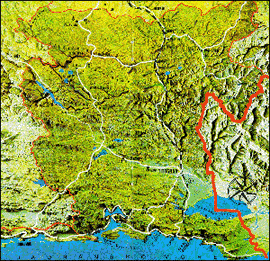
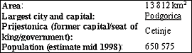
On this map the name of the capital is still Titograd. In 1992, its name was changed to Podgorica.
The geography of Montenegro is inseparable from its history. Its natural features have endowed the Montenegrins with their ability to survive in the harshest of conditions. In days of old while great empires were carving up Europe by fire and sword, Montenegro found itself in the way of most of them. Its people fought many wars, losing occasionally the most beautiful parts of it and were forced to flee many times into inaccessible arid hills, but they were never vanquished.
Montenegro has always been a big problem for cartographers as it was impossible to write all the letters of its name into the small space assigned to it on the map.
| I. Nature: A priority |
· International conventions, laws and urban-development protect Montenegro's numerous national parks and beauty spots, which cover 28% of the countries territory.
· The city of Kotor and Kotor-Risan Bay was placed on UNESCOs endangered world cultural heritage list in 1979.
· Durmitor National Park was listed on UNESCOs national heritage list in 1980.
· The Tara river basin became part of UNESCOs Man and Biosphere program in 1977.
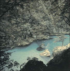
- Canyon Moraca -
Montenegro's Environmental Protection Act applies to monuments of nature such as canyons and gorges, natural preserves (plant and animal habitat), beaches, man-modified natural objects and other natural objects whose protection is considered to be in the interests of the state.
· A special decision by Montenegro's Institute for Environmental Protection Ensures special care for 52 plant and 314 animal species in Montenegro, including all bat species.
· Montenegro was declared "Ecological State" (+see Declaration of the Ecological State)
| II. geographical positioning |
By its geographical position, Montenegro belongs to the central Mediterranean that is Southern Europe.
On the southeast, it borders with Albania. On the south, it is separated from Italy by the Adriatic Sea, whereas its western neighbors are the former Yugoslav republics of Croatia and Bosnia and Herzegovina
The distance between the Montenegrin capital Podgorica and Rome is around 500 km by air, from Paris and Berlin it is around 1,500 km, from Moscow almost 2,000 km, and 7,500 km from New York.
The two farthermost points of the country are only 190 km apart from each other in a straight line, but between them the northbound air streams of Africa meet the southbound from the Polar circle.
The name of Montenegro (Black Mountain) was probably derived from the thick "black" forests that in the mediaeval times had been covering Mt. Lovcen and other alpine areas of the "Old Montenegro". This name was first mentioned in 1276, after which it has gradually replaced the former names for this geographic and administrative area - Duklja and Zeta. Italian sources also record the names of Montagna Nera, Montenero, or Monte Negro - wherefrom Montenegro was probably incorporated into the West-European languages.
During the reign of the Crnojevic family, the last rulers of the state of Zeta, there was a strong Turkish onslaught on the territory that forced them to move their seat to the mountains. After the fall of this dynasty the name Crnojevica Gora (the hill of the Crnojevics) remained, and was later shortened to Crna Gora which means Montenegro in Serbo-Croatian.
H.F Winnington-Ingram (c.1844), British Admiral had the following impression of the landscape: "The land can be proud of the wondrous beauty of its regions. Mountain surpassing mountain and graceful wild valleys are its characteristics marks."
There are also several legends about the name of the country and where it comes from. According to one of them, it owes its present name to seafarers, who spotted the region first and saw the mountains enrolled in clouds and constantly beaten by the elements, and it appeared to them as huge dark elevations. Hence the "black mountain" according to another legend, the present name originated with its enemies, as an allusion to the grim fate befalling their aims in the mountains of this country.
| III. Contrast in landscape |
That the observation of the Italian botanist Baldaci about "the poetic and the pathetic characteristics" of nature in Montenegro was not a lyrical overstatement it is supported by the fact that Montenegro is both a seaside and continental, mountain country. Montenegro is the country of natural rarities which is shown throughout the four clearly differentiated geographic regions within its small area.
To show the real diversity of the landscape, we chose a quote from the French writer L. Asserin:
"The contrast between the serene beauty and charming waters of the Adriatic and the brutal bare mountains of Montenegro inspire fear. On one hand the blue waters of the bay, the most bewitching in Europe, the green fertile earth with the glean of small white towns set along the coast; and on the other hand a sea of gloomy, bristling mountains with their grey clouds, decorated only with small plots of cultivated land."
1. Seaside
2. Rocky tablelands
3. Central Montenegrin depression
4. High mountains
5. Forests
| 1. Seaside |
The Seaside presents a striking contrast to the other three regions, and makes the Mediterranean "facade" of Montenegro.
<- Cliffs of Budva -
The width of the Adriatic Sea is greatest between Montenegro and Southern Italy (around 200 km), and that part of the Adriatic is at the same time the deepest (greatest depth is 1,330 m at the point 120 km south-west of the Bay of Kotor).
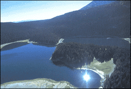
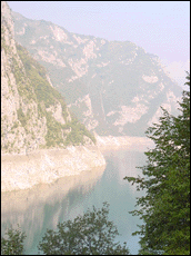
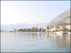
The length of the coastline is 293.5 km, of which 52 km are beaches. The Montenegrin seaside is a very narrow strip of land (2-10 km wide), separated from the inland by high and steep limestone mountains of Rumija, Sutorman, Orjen, and Lovcen. The coast is very indented with numerous bays and coves. The largest, and most impressive is the Bay of Kotor, which is the world's southernmost fjord.
| 2. Rocky tableland |
A special geomorphologic region in Montenegro is the picturesque limestone area that is in complete contrast to the Seaside, which it literally overhangs.
Plants and animals are scarce here, and patches of fertile land can be found in karst depressions - poljes - and crater-like hollows - vrtaces.
Limestone easily drains, so even the heaviest annual rainfalls have little effect here. An interesting fact is that it is in this area, in Krivosije above the Bay of Kotor, that the annual rainfall is around an average of 480 mm/day, which makes it the rainiest area in Europe. This creates a paradox: heavy rainfall, but almost none water for people.
Situated in this region is Lovcen National Park.
| 3. Central Montenegrin depression |
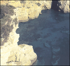
Lake Skadar, the fertile Zeta plain with the Zeta River valley, and the Niksic field (polje), comprise the third geomorphologic region of Montenegro. This is a lowland and the only plain area in Montenegro.
The average altitude of the Zeta plain is 40 m in its northern part, while the Niksic plain, that is part of it, is 500 m higher.
-Lake Skadar-
The fertile lowlands along the river valleys are the ideal place for human settlements, so that the Zeta plain, the Zeta River valley, and the Niksic field record the highest concentration of population in Montenegro. The two largest cities in the Republic - Podgorica and Niksic - are situated here. In this area is the Lake Skadar National park is situated, the largest in the Balkans.
There are 40 lakes in Montenegro and its rivers have still remained the purest of Europe's.
| 4. High mountains |
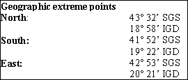
The northern part of Montenegro is the area of high limestone mountains. From the tablelands and plateaus of 1,700 m in altitude, rise vast mountain ranges and ridges of over 2,000 m (Durmitor, Bjelasica, Komovi, Visitor). These mountain ranges are rich in pasturelands, forests and numerous mountain lakes, of which there are 29 in Montenegro. The rivers Piva, Tara, Moraca, Cehotina and their tributaries have cut deep narrow channels in the limestone - the canyons, whose beauty and size are unique. In its size, the canyon of the Tara is the second largest in the world.
In this region there are two magnificent national parks - Biogradska Gora and Durmitor.
If you drive northwards of Podgorica and its almost tropical temperatures, it will only take you 20 minutes to reach an area with a continental climate.
- River Tara -
The Tara is the longest Mountain river in Montenegro (150 km). The canyon of the river is about 80 km long cut between the mountains of Sinjajevina and Durmitor, the average depth is about 1000 m, near the town of Obzir it reaches the depth of 1300 m which makes it the deepest and longest canyon of the world after the Grand Canyon of Colorado. The Tara canyon is a perfect example of wild nature.
The entire northern part of Montenegro is an oasis of untouched nature which is waiting to be explored. The strategy of the country has been, in recent years, to give priority to the production of health food and tourism and to use its natural resource more wisely and economically, which resulted in the adoption of the Declaration of the Ecological State in 1991.
| 5. Forest |
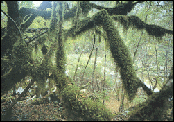
<- Virgin Forest -
Eighty percent of the territory is comprised of forests, natural pasturelands and meadows. A total of 2833 plant species, many of them unique, grow here which makes up nearly a quarter of the entire European flora! All that in a mere 0.14% of the continents territory.
Four national parks and a number of other places of flora and fauna, many of which are protected by law, cover almost 1/3 of the territory.
| IV. Regions of Montenegro |
Average temperature in January: 5°C
Average temperature in July: 30ºC
|
| 1. Facts about the main cities and municipalities of Montenegro |
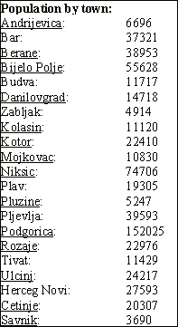
Montenegro is comprised of 21 municipalities that are larger than the usual size of municipalities in Western Europe. Niksic is the largest with 2056 sq.km. and Tivat is the smallest with 46 sq.km.
Podgorica
The administrative, commercial, cultural, and social centre of the republic since 1946. The city was razed to the ground during World War II after having been bombed by all sides. Later it was rebuilt and named Titograd after its architect and the former Yugoslavia's famous 20th century leader. After the fall of the SFR Yugoslavia in 1992 the name was reverted back to Podgorica.
Population: 152 025
Economy: Aluminum Plant KAP, Tobacco Factory, petrochemistry, chemical industry, textile industry, pharmaceutical industry.
Andrijevica
Population: 6696
Economy: Marble exploitation and manufacture
Potential Investments: Factory Konovi, Produces candies and caramels. Agriculture potentials not used.
Bar
The old city dates from the 9 century. The city is of special importance because of its seaport with connections to Italy, Greece, and direct railway link: Bar-Belgrade.
Population: 37 321
Economy: Port of Bar with a capacity of 6 million tons per year
Potential Investments: Tourism, nearly 9 km of sandy beach. Not enough hotel capacities.
Berane
Former industrial town.
Population: 38 953
Economy: strong cuts in jobs in the last 10 years.
Potential Investments: Paper and cellulose production, agriculture.
Bijelo Polje
The 3 largest town in Montenegro, situated near the Serbian border. Located on an important traffic route and connected with the railway Bar-Belgrade.
Population: 55 628
Economy: Rich in mineral and hot water springs, textile production, building machinery, metalworking.
Budva
The oldest town in the Montenegrin coast, it was founded more than 2500 years ago.
Population: 11 717
Economy: Tourism
Potential Investments: Accommodation, tourism.
Cetinje
Former capital and residence of Prince-Bishop Njegos and King Nicola. Museums, the former royal palace, and the Academy of Fine Arts is situated here.
Population: 20 307
Economy: Factory of Obod Household Appliances
Danilovgrad
Situated between the industrial centres of Podgorica and Niksic.
Population: 14 718
Economy: Marble production and export to Italy.
Potential Investments: Agriculture, production of ecologically clean food.
Herceg Novi
Situated at the entrance to the Bay of Kotor. Popular tourist resort. The Northern most city on the Montenegrin Coast, more than 600 years old.
Population: 27 593
Economy: Tourism, recreational tourism at the Institute of Dr Simo Milosevic, Bijela shipbuilding and repair
Potential Investment: modernisation of the Health Institute Igalo, tourism.
Kolasin
Population: 11 120
Economy: Winter and summer tourism areas.
Potential Investment: Forestry
Kotor
Situated in the Bay of Kotor. Included into UNESCOs list of world cultural heritage sites since 1999.
- Kotor on the Bay -
Population: 22 410
Economy: Tourism, Jugopetrol- state owned oil company.
Potential Investments: Tourism, energy sector
Mojkovac
Surrounded by 2 National Parks and the worlds second largest canyon, the Tara canyon.
Population: 10 830
Economy: Mining
Potential Investment: Forestry
Niksic
Situated north of Podgorica, the 2 largest town in Montenegro.
Population: 74 706
Economy: Aluminum/bauxite mines, steel foundry, electric power production and brewery
Potential Investments: Fishing and hunting tourism needs to be developed.
Plav
Near the border with Kosovo and Albania. Suffered from NATO bombing.
Population: 19 305
Economy: Forestry, Agriculture
Potential Investments: Agriculture could be better developed with a potential to produce for export. Good conditions for alpine tourism, but not developed at all.
Pljevlja
Near the Serbian border. Very rich in natural resources.60% of mines and 20% of wood is concentrated in this territory.
Population: 39 593
Economy: Mining. Thermo-power plant. Forestry
Pluzine
Situated on the road from Niksic to Sarajevo, near the Bosnian border.
Population: 5247
Economy: Hydropower plant
Rozaje
On the border with Kosovo.
Population: 22 956
Economy: Wood and Forestry
Potential for Investment: Mountain and recreational tourism.
Savnik
Situated in the valley of Mount Durmitor. The least developed region in Montenegro.
Population: 3690
Economy: Agriculture and stock breeding. Cement factory.
Tivat
Small but typical Mediterranean country. Has an airport and is an important holiday destination during the summer. Thanks to its accessibility, in the distant past the Tivat Bay was convenient for setting up the settlements whose inhabitants were mostly fishermen and mariners.
Population: 11 429
Economy: Tourism, with the island of Sveti Marko that used to be a Club Med resort.
Ulcinj
The most southern town on the Montenegrin coast. Very pleasant climate, 288 sunny days per year and a 12 km long sandy beach make it an attractive holiday destination.
- Ulcinje, Town Beach -
Population: 24 217
Economy: Tourism, Agriculture, Fishing, Salt manufacture used to be the best in the former Yugoslavia.
Potential Investment: In tourism sector, since this is the longest sandy beach of the Adriatic!
Zabljak
Situated on Mount Durmitor and is part of the National Park. It is the highest town in the Balkans. The territory of the municipality includes the second deepest canyon of the world, the Tara Canyon.
Population: 4914
Economy: Stock breeding, dependent on winter and summer tourism
Potential Investment: Tourism sector
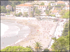
| 2. Main towns on the seaside |
Coastal tourism is developed mainly in the south of the country. There is a string of beautiful beaches and charming old towns. The most recognizable and famous is the little town of St. Steven. Once a small fishing village, it was turned into an exquisite, luxurious hotel area where all the rich and famous of Europe has spent their vacation starting with Winston Churchill to Gianni Versace. As a matter of fact, it looks more like a small fortress with little squares, narrow streets and a centuries old atmosphere that makes it even more exquisite.
Ulcinj
The southernmost of all cities, it is divided from Albania by the river Bojana. The coast is mainly sandy, dominated by the 13km. long Great Beach. There is also a Small Beach (650m) inside the town with very fine sand.
Bar
Is a harbour town with active daily traffic to Bari (Italy). The old town of Bar is also worth visiting it. In Sutomore you can find a nice beach with hotels and holiday resorts. The biggest concentration of olive trees is in the area of Bar, with the oldest of them, a 2000 year old tree!
Petrovac
Further up to the north, a small town but one can find here everything one needs to have a good time.
The next stop is the Budvanska Rivijera
The most known tourist area on the Montenegrin coast. Here we can find Sveti Stefan (St. Steven), The holiday destination!
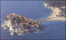
- Sveti Stefan -
Milocer
Only 500 metres from St. Steven, here we can find the Kings summer residence and the Queens Beach, that are both now turned to serve the needs of the tourists.
Becici
Has a beautiful long (2,5 km) sandy beach. All the hotels are of the highest quality here. In Paris it has won Grand Prix as the most beautiful beach in Europe.
Budva
The metropolis of Montenegrin tourism, this is the place where everybody goes, young or elder, you can not miss this town. It is also famous among the young for its nightlife. The Old Town, is a beautiful small village full of hotels and restaurants and cafes. The houses and streets of the Old Town have been preserved and look like they have looked hundreds of years ago. The Budva fortifications, once a protection from enemies, are today a witness of a centuries-long existence and a gazebo offering magic pictures to the eye.
Boka Kotorska (The Gulf of Kotor) is the next stop. You will be reaching it by passing by Tivat, the only coastal town that has an airport in Montenegro. See the old part of Kotor, its worh it.
The last, but not the least, is the town of Herceg Novi, a 600 years old coastal town, with its Mediterranean Health Centre in Igalo. It has the most sunny days in the year compared to other cities along the coast.
| V. Climates |
There are four climatic types with a variety of microclimatic changes and variations. Being in the middle between the subtropical and sub polar regions, the air currents from Africa going north and the polar fronts moving towards the South replace each other over Montenegro.
The contrasts in the land (topography) are related to climate. While the Mediterranean climate prevails at the seaside, in the closest hinterland, only few air-distance kilometers away, the dominant climate is Continental. The Dinaric range of mountains (Orjen, Lovcen and Rumija) rises steep above the coast, and just like a gigantic backdrop largely prevents the penetration of the Mediterranean climate into the inland.
At the seaside region the average Summer temperatures are between 23.4ºC and 30ºC. Summers are usually long and dry, winters short and mild. Along the valley of the River Bojana, over the basin of Lake Skadar and upstream the Moraca, waves of intense heat penetrate to Podgorica, making it the warmest city in Yugoslavia.
In central Montenegro, in the regions of Zetska and Bjelopavlicka plains, July temperatures are 26.4º (in Podgorica), and 25.4º (in Danilovgrad). The absolute maximum can sometimes reach 43ºC. The average January temperatures are around 5ºC, with the absolute minimum of -10ºC.
In the region of high limestone mountains, the climate is typically sub alpine - with cold, snow-abundant winters and moderate summers. While along the Montenegrin seaside and in the basin of Lake Skadar snow is a rarity, on Mt. Durmitor it can fall up to five meters. In the northern parts of Montenegro, and particularly in the high mountains, due to low evaporation, the snow remains for several months and sometimes even over the whole year. |

