Getting to know Falcon State is like having a taste of Venezuela on a smaller scale, due to the varied attractions and many different landscapes to be found here. Its long Caribbean coast has a sharp contrast with its mountain’s lush vegetation. The Paraguaná Peninsula, open to winds and full of optimistic people, is an extensive level ground with Santa Ana Hill at its heart; the hill to overlooks the extraordinary green shades of tropical rain forest contrasting with the deep blue waters of the peninsula’s coast.
Coro and Puerto Real La Vela, registered by UNESCO in the list of the World Heritage, throb with history reminiscences and safeguard a cultural legacy of undeniable value. Western Falcon - a sleeping giant with immense potential in marine farming. Mining, cattle raising and water sources-offers magnificent alternatives for regional business.
The eastern coast –heart of the country’s tourist developments-, the fertile lands in the central-eastern municipalities, and the southern mountain ranges, offer an extraordinary scenery that is part of everyday life for these friendly and hardworking people. Today, these descendents of the of the Caquetio Indians are open to world business with ambitious projects like Paraguaná Refinery Complex, the tax-free zone for tourist investment, the integrated planned tourist center of Chichirivichi, the western coal project and the revival of Coro and la Vela’s historic quarters.
Falcon is an ideal place for recreation, adventure, investment and family activities, and a promising land that would make anybody agree with us: Falcon is indeed a fabulous place to explore.
General Information
Location:
Falcon State is located in the northwest region of Venezuela. The Caribbean Sea bathes its 685-kilometers coastline, while its continental area is formed by flatlands, hills and mountain ranges that belong to the Coriano Mountain System. It has an area of 24,800 kilometers and is bordered by Zulia, Lara and Yaracuy states.
Climate:
In the lower areas, and on the coast precipitation is scarce (between 400 and 900 mm) and the rate of evaporation is high, the median temperature is from 27 to 28 °C (81 to 82 °F). It usually rains fluctuate between 1,200 and 1,300 mm and the temperature in the higher zones ranges from 16 to 18 °C (61 to 64 °F).
Services:
Falcon State has a total of 6.583 Km of principal and local highways with their branch lines. Highway N°3 goes from east to west and communicates falcon with Yaracuy State; this route is connected with the majority of the state’s secondary roads. Highway N°4 runs from north to south and communicates with Lara State. Falcon has two international airports: the Jose Leonardo Chirinos outside Coro and the Josefa Camejo in Las Piedras close to Punto Fijo. It also has various ports, mostly dedicated to the oil industry’s activities and fishing business. Parts of the route around the coast of the Paraguaná Peninsula are not paved and should only be traveled by four-wheel drive vehicles.
Lodging:
In the area of Coro and Punto Fijo you can find lodging in executive hotels. In more tourist zones like Tucacas and Chichiriviche, besides luxury hotels with all the services there are also inns of various types and prices. In the mountain towns of the San Luis Sierra, as in Adicora and El Supi in the Paraguaná Peninsula, you can stay in moderately priced inns or rent a cabin for the seasons.
Economy :
Falcon economy is essentially based on Tourism, Life stock, Agriculture and Fishing.
The landscape
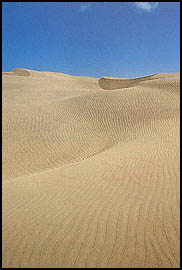
The sea acquires unbelievable shades of green and blue off the coast of this Caribbean state. The golden sands are not just a division between the land and the sea but let themselves be hauled inland by capricious winds to pile up in enormous dunes known locally as medanos. The level coastlines are followed by softly undulating terrain announcing the higher southern range mountains. Numerous caves, chasms, rivers and submerged lakes originate in these limestone mountains. Not only they are an important water source for the state’s needs, but also give this region an intriguing and magic aura. The green northeastern valleys offers their lands for raising livestock and the development of coconut plantations, that make a difference with the enormous extensions of semi-desert lands covered with xerophytes vegetation that predominates toward the north. Like a wayward teenager looking for independence, the Paraguaná Peninsula detaches itself from the continental coast of falcon, linking to mainland through a narrow sand strip known as the isthmus of the medanos, or isthmus of Coro. The peninsula’s flat relief is interrupted by Santa Ana Hill, which juts up to a high altitude and is clearly visible from distant points of the peninsula. The hallucinating landscape of the sand dunes is most noticeable in the thin strip of the isthmus’ area, protected by the Medanos Of Coro National Park, guardian of this natural scenery of unique beauty.
Customs and Traditions
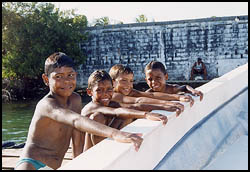
Just as topography defines the landscapes, this land’s inhabitants are influenced by the environment they live in. In lower lands and in coastal areas people are courteous and noble, their skin weather-beaten by the sun, salt and wind. Those living in the mountains have been traditionally regarded as visionaries and fighters, but also as great storytellers of magic tales about elves dwelling in the caves.
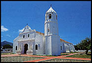
Today’s Falcon State was formerly known as the Province of Coro. The territory has been a witness of significantly historical processes and the cradle of outstanding personalities of the Venezuelan independence movement. Coro, its capital, was founded in 1527 and is called the "Mother City", because it was the first stable human settlement of the South American continent. Its designation as part of the world’s cultural heritage, together with La Vela, was in recognition of its importance in America’s urban development and validates the architectural value of the buildings located in its historical centers. The sturdiness and versatility found in he architecture of Coro and in the rest of Falcon State is the result of the mixture of Spanish and Indian construction techniques like bahareque, adobe and tapia. Bahareque, mud walls built up within a frame of wooden rods, is still used in rural areas and in more modest constructions of Coro and La Vela. Adobes, sun-dried bricks made of mud, are present in historic landmarks like the Casa de las ventanas de Hierro (the House of the Iron Windows), the Casa del Sol (the House of the Sun), the Balcon de los Arcaya (the Arcaya’s Balcony) and the Casa de los Senior (the Senior’s House). Tapia, clay earth massed and tamped down into mold, is another technique used in the San Francisco Church, La Salceda Convent and the Cathedral.
Falcon’s tourist attractions are not limited to its original architecture. Its crafts and folklore are also outstanding. The craftsmen who live in the towns around Coro specialize in furniture made with woods from cardon, palo de arco and curare trees. Woodworks enhanced with seats made with woven sisal fibers, cowhide or even goatskin. Clay fashioned by the industrious hands of the habitants of Paraguaná is made into objects of daily domestic use, applying the same techniques used by the Caquetio Indians. On the east coast the most popular handcrafted items are baskets made with natural fibers like enea, cocuiza and rattan, and hammocks made with thin cotton twine.
Falcon’s typical cuisine offers a variety of flavors in specialties like talkari de chivo (goat meat stew), nata (milk cream), arepa pelada (Venezuelan " muffins" made with corn flour) and dulce de leche de cabra (goat milk sweet). Tourist also can have a taste of Falcon watching folk festival in which African, Indian and European cultural traits mingle. Among these celebrations are the Danza de las Turas (turas are flutes made of canes), which has its origin in an Indian dance related to the hunting season and corn crop gathering. It takes place in the mountain towns of san Pedro, El Tural and maparari on September 23rd. and 24th. The drum dances in the cities of Coro, La Vela and Puerto Cumarebo are very gay and colorful, and the celebration of Fool’s Day on December 28th. In La Vela, with masqueraders parading through the streets, reach a display similar to the world’s great carnivals.
Falcon State’s Eastern Coast
Falcon State’s eastern coast is located to the southeast of the state, between the towns of Tucacas, Chichiriviche and San Juan de los Cayos, capitals of the Municipals, Silva, Monsignor Iturriza and Acosta. With a coastal border of 70 kilometers, and a 337,47 km˛ surface, the region receives approximately more than half a million tourist per year (according to the numbers given by the OCEI and Tourism Secretary).
Protected Zones
The zone is extremely protected because of its environmental value; among the areas of natural reserves are the following:
Morrocoy National Park: Covers 32.090 hectares of the coastal sector to the northeast of the Triste Gulf.Caure Wildlife Refuge: the first RAMSAR stop in the country, with 11.853 hectares of extension.Protected Zone: Made up of a 450 hectares area.Forest Reserve: An area made up of a 47.640 extension.Hydraulic Reserve: A protected area of the zone.
Sites of Interest
Morrocoy, between mangroves and coral
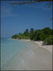
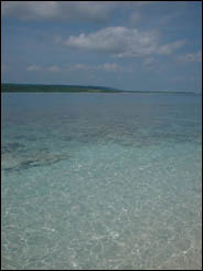
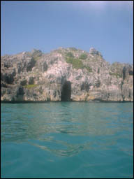
Morrocoy, an area of breathtaking beauty on the extreme east coast of Falcon, is made up of a series of cays and islets of coral origin, with white sands beaches, a turquoise blue sea and dense mangrove forest where sea birds proliferate as they find refuge and breeding sites. The government has granted protection to this extensive zone through the figure of Morrocoy national Park, and also to the Cuare Kathy Phelps Wildlife Refuge. Morrocoy is outstanding for the quality and attractiveness of its beaches, perfect for many open-air activities like camping, and for water sports like scuba diving and sailing. Cuare is an ideal site for nature watching and ecological tourism, because the refuge area permits bird watching, photography, hiking and boat trips along the established navigation routes. Access to this area is from the Moron-Coro Highway where it passes by the towns of Tucacas and Chichiriviche. From Tucacas you can go in launches or small boats to the cays and beaches in the southern sector of the national park like Punta Brava, Paicla, Playa Norte, Pescadores and Sombrero. From the dock facilities in Chichiriviche you can go to Muerto, Pelon, Sal and Borracho cays in the northern area. On some of the cays you will find cafeteria services, beach umbrellas, chair rentals and ranger stations.
Some interesting sites in the wildlife refuge are Chichiriviche Hill, or El Indio and la Virgen cave in the Cuare Cove. There you will find Nuestra Señora de la Roca Marine Sanctuary, and shallow water lagoons where you can see huge flocks of wading birds like flashy herons, ibises, and flamingos. These lagoons are found on both sides of the highway to Chichiriviche, and there are observation points where you can view these interesting birds with binoculars. To the north of Chichiriviche you will find the towns of Tocuyo de la Costa, Boca de Tocuyo, Boca de mangle and San Juan de los cayos, whose inhabitants make their living from coconut tree plantations and fishing. The Tocuyo River is an important watercourse, which runs into the sea at the site of the town of Boca de Tocuyo. From colonial times, until the construction of today’s modern roads, it served as way to get to the sea for the inland inhabitants of the country’s Western region. From San Juan de los Cayos, the highway takes you inland and passes by Capadare and Mirimire. This valley. Nestled between two rows of limestone hills, us startling for the exuberance of its vegetation. Other villages worth visiting are Pititu, Pueblo Cumarebo-one of the oldest of the region whose church was declared a national monument in 1960- and Puerto Cumarebo, an old, traditional port with narrow streets and colonial style houses.
Paraguaná Peninsula, home of the winds
Before getting to Coro there comes up a detour heading north, which takes you to the Paraguaná Peninsula by the isthmus of the medanos. The remarkable scenery of the sand dunes, which the win carries from one side of the highway to the other, marks the southern part of the isthmus. These are the medanos of Coro. This attractive and beautiful area is part of the Medanos de Coro National Park, with 91.290 hectares that offer protection to marshy coasts in the southeast and marine sector to the north.
At the northern end of the isthmus there is a cross roads from which you can take different routes. The northern route, bordering the eastern coast, takes you to Adicora. This fishing village, which now makes its living from tourism, was main port f the peninsula from colonial times to the 1940’s. The strong influence of the neighboring Netherlands Antilles (Curacao, Aruba and Bonaire) can still be noticed in its houses’ architectural features. Adicora Beach is ideal for windsurfing and each year it houses national and international competitions. The coastal highway goes up to the beaches of buchuaco, El Supi and Tiraya, which are usually filled with vacationers coming from Midwestern Venezuela on weekends and during the longer holidays. To the north, in Las Cumaraguas, the salt lakes reflect pink and violet hues. There begins a route, which borders the coast going through thickets, sandy areas and coral beds, and is only suitable for four-wheel drive vehicles. This road takes you to San Roman Cape, the northernmost point of the peninsula and of continental Venezuela. From here the road continues toward the southwest taking you to Punta macolla where the Gulf of Venezuela begins.
On the west coast of the peninsula you will find the well-known industrial and urban axis located among the towns of Amuay, Judibana, Punto Fijo and Punta Cardon, where the refineries of Amuay and Cardon were united in 1997 to form the world’s biggest oil refinery complex. The Gustavo Rivera Zoo, located in Punta Cardon, exhibits various Venezuelan animals threatened by extinction like the Helmeted Curassow and the Spectacle Bear.
If you choose to visit the peninsula’s interior you will find picturesque villages like Moruy that were inhabited long ago by the Caquetio Indians. There you can admire the traditional Falcon architecture and Caquetio crafts. Jadacaquiva and Los Taques have been witnesses and participants of the state’s history. Jadacaquiva was General Juan Crisostomo Falcon’s birthplace and Los Teques was the village visited by Alonso de Ojeda during his second trip to America in 1502 and is considered the first establishment built by the Spanish on the American continent. Aguaque, close to Pueblo Nuevo, is the birthplace of Josef a Camejo, a young Falcon patriot of the independence years. The house she was born in has been restored and declared a national historical monument in her honor. Pueblo Nuevo is the centre of commercial and livestock activities; the famous goat milk sweets are made there, as well as furniture made from cardon wood.
To the south, on the slopes of the only hill that can be seen on that flat land of the peninsula is the town of Santa Ana, one of the oldest in all Venezuela. The end of the 17th century finished the construction of its three-aisle church of solid columns. Upon leaving Santa Ana you can notice the progressive changes in the climate and the vegetation: a dry environment with spiny vegetation predominates on the lower parts, while on the higher parts humidity favors the development of forest vegetation with a variety of epiphytic plants like muss, ferns and bromeliads. Higher-level trees and palms are dwarf examples of the same species growing on the slopes. They never reach a normal height due to the strong winds blowing from the sea.
Coro - La Vela World Heritage
Santa Ana de Coro, Founded around 1527, was the first permanently inhabited city and is the oldest in he country, its first political capital and the seat of the first diocese in South America. In 1993, UNESCO declared Coro and its Puerto Real La Vela as part of humanity’s cultural heritage.
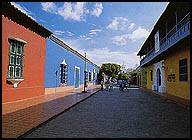
The city and its port make up an architectural whole, which harbors important examples of the construction of traditional human settlements, which correspond to a certain historic period. The original plan of Coro’s streets- still visible today- reproduces in some way the typical arrangement of Andalusian and Canarian cities at the end of the 15th Century, and also numerous buildings of great significance made with the so-called poor materials, like bahareque and adobe. La Vela de Coro offers an amazing repertory of architectural elements made up with colonial features and makes an urban landscape of remarkable architectural unity.
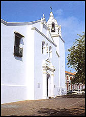
As you walk around Coro’s colonial quarter, religious constructions stand out of the city’s profile. Among these the Cathedral, seat of the First Diocese, is an historic national monument dating back from the 16th. Century. It is the first cathedral built in the country and the most important religious building of Venezuela until 1638, when the capital was moved to Caracas. The convent and Church of San Francisco is one of the few surviving examples of this religious order in the country, and now is the seat of the Lucas Guillermo Castillo Museum of Coro (Diocesan Museum). San Clemente Church, one of the few chapels built with the shape of a cross, was finished in 1538; however, like all churches in Coro, it suffered constant attack to French and English pirates during the 16th and 17th Centuries so had to de restored around 1758. San Nicolas de Bari Church, located n the outskirts of the old city, has just one aisle and still maintains its original profile. Alongside this church is the city’s oldest cemetery.
There are also many important civil buildings in the colonial zone where the same basic scheme is maintained, as found in the colonial cities of the rest of Venezuela. The house’s rectangular design encloses an inner patio surrounded by corridors, along which are located private rooms and social spaces. Decorative details and other fancy features are found mostly in the doorways and the windows, although in some of Coro’s houses a full-length roofed balcony was incorporated in front, a typical design in the coastal colonial cities. The house known as the balcon de los Arcaya (the Arcaya’s balcony) was built in the 18th. Century and suffered much damage during the War of Emamcipatio. Now, after the Arcaya family donated it to the state, this place now houses the Museum of Popular Ceramics. In the house known as the Balcon de Bolivar (the Bolivar Balcony) or the Balcon de los Seniores (the Senior’s Balcony), architectural elements from the Netherlands Antilles and from the Canary Islands comes together. This house was built around 1754 and Simon Bolivar, the Libertador, lived there after the War of Independence; today it is the seat of the Contemporary Art Museum of Coro. The Casa de las Ventanas de Hierro (the House of the Iron Windows) has only one floor and its doorway front measures almost eight meters in height; the huge iron windows, which give it its name, were brought from Seville in Spain. This house belongs to the Tellera heirs and is noted for never having been sold in its 230-years of history; it now houses the Foundation for the Casa de las Ventanas de Hierro Museum. A large sun with a human face decorates the doorway of the casa del Sol (the House of the Sun). This house was the seat of a branch office of the Guipuzcoana Company and served as lodging for Generalisimo Francisco de Miranda when he arrived at Coro in 1806. The Casa del Tesoro (the treasure House) owes its name to a legend made up around the fortune f its owner; it is also known as the Casa del Obispo (the Bishop’s House) because Monsignor Mariano de Talavera was born there. In the Casa de los Torres (Los Torres’s House), the hallway pavement is made of beef bones and small round stones; this is the only remaining example of this type of binding element, once commonly used in the city.
La Vela, founded in 1528, is just 10 minutes away from Coro. Among its most important buildings are the Casa de las Aduanas (Customs House), the church and the Monumento a la Bandera (Monument to the Flag) Square. About five kilometers ahead is the Carrizal Church, built in the 18th. Century and dedicated to the veneration of the Virgin of Guadalupe.
To round out this historic tour you can visit the Dr. Leon Croizat Xerophytic Garden, located on the road between Coro and La Vela. It is considered to be the most important of its type on the continent. There are groups of desert plants on display along with an interesting collection of exotic species like the Welwihchis mirabilis, which develops the largest leaves in the world, and the baobab, which is Africa’s symbolic tree.
Coro’s historical center
Coro Sierra, where waters are born
To the south of Coro the topography begins to undulate. The roads winds around the El Isiro Dam, the most important source of water for the city and the Paraguaná peninsula, and then goes up toward the sierra of Coro also known as the sierra of San Luis. This route takes you to picturesque villages and breathtaking natural landscapes. Embedded in the mountain range, tiny villages are surrounded by exuberant vegetation, the climate is cool and there are numerous water sources and falls. San Luis de Cariagua and Cabure are typical towns where the urupagua grows; this is a native tree of this region, which has a bitter-tasting fruit.
On the way to the mountains, dry forest on the lower slopes gives way to the humid and leafy forest, which grows on the higher areas. On the heights, the cloud forest takes over. Juan Crisostomo Falcon national Park, also known as Sierra d San Luis national Park protects this important environment. The park’s 20,000 hectares provide an important source of water for the rest of the state because they protect the headwaters of the region’s main rivers. Rainwater erodes the mountain limestone and etches out numerous caves and chasms with steep, rugged walls, inside of which subterranean lakes have been formed. Mysterious legends and popular beliefs about elves that live in them have been made around these caves for the purpose of protecting the vital fountains of water. Close to Curimagua you find the opening to a vertical shafts known as haiton del Guarataro, which is over 350 meters deep and should only be explored with speleological guides and proper equipment.
South of the sierra, some 15 kilometers from Santa Cruz de Bucarai, you can find an area of uneven relief whose distinguishing mark is an enormous fault, which divides the mountain range in two. Over this fault, Mother Nature has carved an astonishing bridge called Puente de Piedra (Stone Bridge), and adds special charm to this little known spot. In the same place you will find the openings of the cave shafts of Elda Hernandez and Antonio Jose Lopez. Cueva de la Quebrada El Toro National Park protects this mountainous area, whose main point of interest is a spectacular cave 1,200 meters long, and El Toro Gorge, the largest subterranean watercourse known in the country. Although access to the place is rather difficult, more tourists are heading for the cave, as well as speleology lovers and climbers.