 GEOGRAPHY GEOGRAPHY |
 Environment Environment |
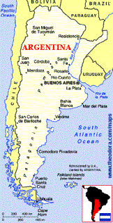
Argentina forms the eastern half of South America's long, tapering tail. It is the eighth largest in the world, and the second largest on the South American continent.
It borders Chile to the west (separated by the Andean Cordilleras range) and Uruguay, Paraguay, Brazil and Bolivia to the north and east (separated by rivers). It also shares the offshore island territory of Tierra del Fuego with Chile, and continues to dispute the ownership of the Islas Malvinas (the Falklands to the Brits). Argentina's topography is affected by both latitude and altitude, and is accordingly varied.
The country can be divided into four major physiographic provinces: the Andes to the west (with arid basins, grape-filled foothills, glacial mountains and the Lake District), the fertile lowland north (with subtropical rainforests), the central Pampas (a flat mix of humid and dry expanses) and Patagonia (a combination of pastoral steppes and glacial regions).
Patagonia: a combination of pastoral steppes...
..and glacial regions
Guanaco |
More than twenty national parks preserve large areas of these varied environments and protect wildlife (much of it unique) such as the caiman (or yacaré), puma, guanaco (a lowland relative of the upper-Andean llama), rhea (similar to an ostrich), Andean condor, flamingo, various marine mammals and unusual seabirds such as Magellanic penguins. Thorn forests, virgin rainforests, flowering cacti, extensive forests of monkey-puzzle trees and southern beech are also protected.
Argentina's climate ranges from subtropical in the north to humid and steamy in the centre, and cold in the temperate south. The Andes region has erratic rainfall, flash floods in summer, searing heat, snow at higher elevations, and the Zonda - a hot, dry wind. The lowlands receive sufficient rainfall to support swampy forests and upland savanna, but rainfall decreases from east to west; shallow summer flooding is common in the east. The winter dry season is pronounced, and the summer heat can be brutal. The flat pampas areas are also vulnerable to flooding; Patagonia is mild year-round in the east and glacial in the south
| Argentina's general resources |
Argentina or Argentine Republic, federal republic, southern South America, bounded on the north by Bolivia and Paraguay; on the east by Brazil, Uruguay, and the Atlantic Ocean; on the south by the Atlantic Ocean and Chile; and on the west by Chile. The country occupies most of the southern portion of the continent of South America and is somewhat triangular in shape, with the base in the north and the apex at Punta Dungeness, the southeastern extremity of the continental mainland. The length of Argentina in a northern to southern direction is about 3330 km (about 2070 mi); its extreme width is about 1384 km (about 860 mi).
The country includes the Tierra del Fuego territory, which comprises the eastern half of the Isla Grande de Tierra del Fuego and a number of adjacent islands to the east, including Isla de los Estados. The area of Argentina is 2,766,889 sq km (1,068,302 sq mi); it is the second largest South American country, Brazil ranking first in area. Argentina, however, claims a total of 2,808,602 sq km (1,084,120 sq mi), including the Falkland Islands, or Islas Malvinas, and other sparsely settled southern Atlantic islands, as well as part of Antarctica. The Argentine coastline measures 2665 km (1656 mi) in length. The capital and largest city is Buenos Aires (population, 1996 metropolitan area, 12, 608,046).

| | Resources and Land |
Argentina comprises a diverse territory of mountains, upland areas, and plains. The western boundaries of the country fall entirely within the Andes, the great mountain system of the South American continent. For considerable stretches the continental divide demarcates the Argentine-Chilean frontier. The Patagonian Andes, which form a natural boundary between Argentina and Chile, are one of the lesser ranges, seldom exceeding about 3660 m (about 12,000 ft) in elevation. From the northern extremity of this range to the Bolivian frontier, the western part of Argentina is occupied by the main Andean cordillera, with a number of peaks above about 6400 m (about 21,000 ft). Aconcagua (6959 m/22,831 ft), the highest of these peaks, is the greatest elevation in the world outside Central Asia. Other noteworthy peaks are Ojos del Salado (6893 m/22,615 ft) and Tupungato (6800 m/22,310 ft), on the border between Argentina and Chile, and Mercedario (6770 m/22,211 ft). Several parallel ranges and spurs of the Andes project deeply into northwestern Argentina. The only other highlands of consequence in Argentina is the Sierra de Córdoba, situated in the central portion of the country. Its highest peak is Champaquí (2850 m/9350 ft). Eastward from the base of the Andean system, the terrain of Argentina consists almost entirely of a flat or gently undulating plain. This plain slopes gradually from an elevation of about 610 m (about 2000 ft) to sea level. In the north the Argentine plains consist of the southern portion of the South American region known as the Chaco. The Pampas, treeless plains that include the most productive agricultural sections of the country, extend nearly 1600 km (about 1000 mi) south from the Chaco. In Patagonia, south of the Pampas, the terrain consists largely of arid, desolate steppes.
Lakes and Rivers
The chief rivers of Argentina are the Paraná, which traverses the north central portion of the country; the Uruguay, which forms part of the boundary with Uruguay; the Paraguay, which is the main affluent of the Paraná; and the Río de la Plata (see PLATA, RIO DE LA), the great estuary formed by the confluence of the Paraná and the Uruguay rivers. The Paraná-Uruguay system is navigable for nearly 3200 km (about 2000 mi). A famed scenic attraction, the Iguazu Falls (see IGUAZU), is on the river of the same name, a tributary of the Paraná. Other important rivers of Argentina are the Río Colorado, the Río Salado, and the Río Negro. In the area between the Río Salado and the Río Colorado and in the Chaco region, some large rivers empty into swamps and marshes or disappear into sinks. The hydrography of the country includes numerous lakes, particularly among the foothills of the Patagonian Andes. The best known are those in the alpine lake country around the resort town of Bariloche.
Natural Resources in Argentina
The traditional wealth of Argentina lies in the vast Pampas, which are used for extensive grazing and grain production; but Argentine mineral resources, especially offshore deposits of petroleum and natural gas, have assumed increasing importance in recent decades.
Vegetations and Animals
The indigenous vegetation of Argentina varies greatly with the different climate and topographical regions of the country. The warm and moist northeastern area supports tropical plants, including such trees as the palm, rosewood, lignum vitae, jacaranda, and red quebracho (a source of tannin). Grasses are the principal variety of indigenous vegetation in the Pampas. Trees, excluding such imported drought-resistant varieties as the eucalyptus, sycamore, and acacia, are practically nonexistent in this region and in most of Patagonia. The chief types of vegetation in Patagonia are herbs, shrubs, grasses, and brambles. The Andean foothills of Patagonia and parts of Tierra del Fuego, however, possess flourishing growths of conifers, notably fir, cypress, pine, and cedar. Cacti and other thorny plants predominate in the arid Andean regions of northwestern Argentina. In the north the fauna is most diverse and abundant. The mammals in these regions include the monkey (several species), jaguar, puma, ocelot, anteater, tapir, peccary, and raccoon. Indigenous birds include the flamingo and various hummingbirds and parrots. In the Pampas are the armadillo, fox, marten, wildcat, hare, deer, American ostrich or rhea, hawk, falcon, heron, plover, and partridge; some of these animals are also found in Patagonia. The cold Andean regions are the habitat of the llama, guanaco, vicu_a, alpaca, and condor. Fish abound in coastal waters, lakes, and streams.
« Soils of Argentina »
Soils of Argentina
The soils of Argentina vary greatly in fertility and suitability for agriculture, and water is scarce in many areas outside the northeast and the humid Pampas. The Pampas, which are largely made up of a fine sand, clay, and silt almost wholly free from pebbles and rocks, are ideal for the cultivation of cereal. In contrast, the gravelly soil of most of Patagonia, in southern Argentina, is useless for growing crops. The natural grasslands of this region are used primarily as pasture for sheep. Most of the northern Andean foothill region is unsuitable for farming, but several oases favor fruit culture. In part of the Chaco an unusually saline soil is believed to be responsible for the abundance of the tannin-rich quebracho trees.
| Climate |
Argentina's climate ranges from subtropical in the north to humid and steamy in the centre, and cold in the temperate south.
The Andes region has erratic rainfall, flash floods in summer, searing heat, snow at higher elevations, and the Zonda - a hot, dry wind.
The lowlands receive sufficient rainfall to support swampy forests and upland savanna, but rainfall decreases from east to west; shallow summer flooding is common in the east. The winter dry season is pronounced, and the summer heat can be brutal.
The flat Pampas areas are also vulnerable to flooding; Patagonia is mild year-round in the east and glacial in the south.
Temperate climatic conditions prevail throughout most of Argentina, except for a small tropical area in the northeast and the subtropical Chaco in the north. In the vicinity of Buenos Aires the average annual temperature is a mild 16.1şC (61şF). The January and July averages for this area are, respectively, 23.3şC (74ş F) and 10şC (50şF).
In San Miguel de Tucumán the average January temperature is 26.1şC (79şF) and the average July temperature is 13.3şC (56şF). Considerably higher temperatures prevail near the tropic of Capricorn in the north, where extremes as high as 45şC (113şF) are occasionally recorded.
Climatic conditions are generally cold in the higher Andes, Patagonia, and Tierra del Fuego.
In the western section of Patagonia winter temperatures average about 0şC (32şF).
In most coastal areas, however, the ocean exerts a moderating influence on temperatures.
Precipitation in Argentina is marked by wide regional variations. More than 152 cm (60 in) fall annually in the extreme north, but conditions gradually become semiarid to the south and west. In the vicinity of Buenos Aires annual rainfall is about 950 mm (about 37 in). In the vicinity of San Miguel de Tucumán annual rainfall is about 970 mm (38 in). |

