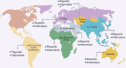
GEOGRAPHY GEOGRAPHY |
With a land of 181.035 square kilometers
Cambodia is one of the smallest country
in of Indochina peninsula. Most of the land
area is arable for agriculture, especially
lowland along sides of Mekong and Tonle
Sap riverbank. The Country shares border,
West and Southwest with Thailand, East and
Southeast with Vietnam, the Northern with
Lao PDR. The Cambodian coastline is 435
km long, close to the gulf of Thailand.
The Country is known as the largest river
fish products from the Tonle Sap (Great
Lake), and Great Mekong River.
| TOPOGRAPHY |
Forests cover about half of the Cambodian
territory; nevertheless the illegal loggings
continue to decrease this surface. Water
or swamps cover about 10% of the land, the
remaining 40% of the country's territory
is arable, even if not all cultivated nowadays.
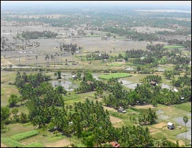
The fertility of the alluvial plain, situated
at the banks of the Mekong River explains
that this region is still the most populated
of the country. The constant flooding are
used are an irrigation method and are ideal
for the cultivation of rice, which is the
main crop of the country. Most of the central
plain is gently rolling land, while in the
south the plain becomes flatter, below the
capital city of Phnom Penh.
The northern part of Cambodia close to the
Thai border is a sandstone escarpment that
runs in an east-west direction for over
300 kilometers and ranges in height from
180 to 550 meters. The Southern land, close
to the Gulf of Thailand, is the costal area
of the country and had become a vital economic
area with the installment of the only seaport
of the country in Kompong Som (or Sihanoukville).
In the southeast of Cambodia lies a highland
region formed by two mountains ranges; the
first one is the granite Cardamom Mountains,
which rise up to 1,500 Meters, the second
is the Elephant mountains, which form a
barrier between the lowlands of the central
plain and the coastal region. In the northeast,
another mountainous region, formed by the
eastern highlands, and held by the hill
tribes is still undeveloped compared to
the rest of the country. These reach up
to 900 meters.
| THE
MEKONG RIVER |
With its source in China, the Mekong River
flows down to Myanmar, Thailand, Laos, Cambodia
and finally to Vietnam. A 600 km stretch
of the river crosses Cambodia from north
to the south. At Phnom Penh the Mekong River
divides into 4 branches: the Upper Mekong,
the Lower Mekong, Tonle Sap and Tonle Bassac.
During the wet season water flows from the
Mekong to Tonle Sap, and during the dry
season the water reverses direction and
flows back to the Mekong and out to sea.
| TONLE
SAP LAKE |
The Tonle Sap Lake is situated in the middle
of the country. Cambodia's 'Great Lake'
is one of the most unique geographical wonders
of the world. Its extraordinary biodiversity
and hydrology make it an ecological wonder.
During the wet season the Tonle Sap is 160
km long, 36 km wide and covers an area of
10,000 sq km with a depth of 12 meters.
|
The Tonle Sap
has abundant supplies of fresh water fish.
For centuries the people of the Great Lake
have been able to catch fish providing the
Khmer people with their major source of sustenance.
For keen bird-watchers, the aquatic habitat
attracts thousand of birds, which flock to
the wetlands before the rains begin in June.
Fish species inhabiting the lake include carp,
catfish (weighing up to 135kg), mussels, herring,
climbing perch and gourami.
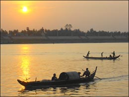
On the banks of the mighty Great Lake and
Mekong Rivers, people have celebrated for
over two hundred years the changing of the
river's flow. During the rainy season the
Tonle Sap River reverses direction, flooding
the lake, and increasing its size almost
tenfold, making it the largest body of fresh
water in Southeast Asia.
During the flooding, water engulfs the
surrounding forest, regulating agricultural
production by ensuring that the countryside
is covered with fresh, fertile silt for
rice cultivation. The silt deposited by
the Mekong River makes agriculture in Cambodia
an important and high yielding activity.
The natural wonder of the Tonle Sap offers
visitors an insight into the century-old
traditions of riparian life and the natural
splendor of the country. A half-day boat
trip on the Great Lake, with its fishing
villages and great views is a very popular
excursion from Siem Reap.
| CLIMATE
|
The Country's climate is close from other
Countries in Southeast Asia; it is dominated
by the monsoon, which are known as tropical
wet and dry because of the distinctly marked
seasonal difference. In summer, moisture-laden
air of the southwest monsoon is drawn land
ward from the Indian Ocean and the Gulf
of Thailand. The southwest monsoon brings
the rainy season from mid May to mid-September
or to early October, and the northeast monsoon
that flows drier and cooler air lasts from
early November to March and then hotter
air prevails in April and early May.
Temperature are fairly uniform throughout
the Tonle Sap Basin area, with only small
variations from the average annual mean
is about 25oC. The maximum mean is about
28oC and the minimum mean about 22oC. Maximum
temperatures of higher than 32oC are common
and just before the start of the rainy season
they may rise to more than 38oC. Minimum
temperatures rarely fall below 10oC. January
is the coolest month and April is the warmest
month.
Typhoons-tropical cyclones- that often devastated
coastal Vietnam, rarely cause damages in
Cambodia. The total annual rainfall average
is between 100 and 150 centimeters, and
the heaviest amounts fall in the southeast.
Rainfall from April to September in the
Tonle Sap Basin and Mekong low lands area
averages 130 to 190 centimeters annually,
but the amount varies considerably from
year to year. The rainfalls around the rivers
basin increase with elevation. It is heavier
in the mountains along the coasts in the
southwest, which receive from 250 to more
than 500 centimeters of precipitation annually
as southwest monsoon reaches the coast.
This area is of the greatest rainfall, however.
Drains mostly to the sea, only a small quantity
goes into river flowing in the basin. The
relative humidity unusually exceeds 90%.
During the daytime in the dry season, humidity
averages about 50% or slightly lower. But
it may remain about 60% in the rain period.
| FAUNA |
Large wild animals that are becoming rare
worldwide are still found in the Cambodian
landscape; Elephants, leopards, tigers and
wild oxen are common. Cambodia most unusual
animal is the Kouprey, a wild forest ox
that was only identified in 1939. Cambodia
has also a very rich and diverse bird life,
including elephant birds such as pelican,
herons, egrets, and cranes and other colorful
ones such as tropical parrots, and kingfishers.
Cormorants, pheasants and grouse are also
part of the common of animal life in the
country.
|