 ENVIRONMENT ENVIRONMENT |
The Slovak Republic (SK) is a landlocked nation-state in Central Europe. More specifically, it is at the geographical center of Europe and is bordered by the Czech Republic, Poland, Ukraine, Hungary and Austria. The capital of Slovakia is Bratislava, "A belle upon Danube", a historical town very well located in the triangle of Prague, Vienna and Budapest. The countryside of Slovakia is very picturesque and varies from Western Slovak lowlands to High Tatras Mountains with Gerlachovsky Peak, the highest point in Central Europe.
| Area |
Both the area and population of the Slovak Republic is approximately half that of the Czech Republic. The total area of Slovakia is 48,845 square kilometers (18,921 sq. miles) out of which only 45.sq. km consists of water (lakes and rivers) and 48,800 sq. kilometers is land. If compared to the United States, the area of the Slovak Republic is about twice the size of New Hampshire. The maximum length of Slovakia from East to West is 428 km (from Zahorska Ves to Nova Sedlica), the maximum width from North to South is 195 km (from Sturovo to Skalite). The lowest place in Slovakia is the Bodrog River in Eastern Slovakia (95 m above sea level), the highest point is the Gerlachovsky peak in High Tatras which measures 2656 m above sea level.
| Natural Regions |
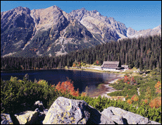
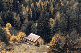
Slovakia is known for its impressive mountain ranges. Many of the country's mountains give way to rolling hills and river valleys, where agriculture, winemaking, and livestock raising are practiced. Slovakia's mountainous terrain has also influenced settlement patterns within the country. You can also find a lot of lakes and rivers here, which attract another kind of tourism. There is a strong culture and tradition that Slovak people are more than willing to share with foreigners.
The Carpathian Mountains, a major mountain range
of central Europe, extends across much of northern
and northwestern Slovakia and encompasses the Little
Carpathians, the White Carpathians, and the Tatry
Mountains, which are the highest of the Carpathian
range. The High Tatras range contains the country's
highest peak, Gerlachovský Štít,
which has an altitude of 2655 m (8711 ft). The High
Tatras also contain one of Slovakia's largest national
parks and are a popular place for skiing and hiking.
Other important mountains include the Low Tatras,
in central Slovakia, and the less spectacular Fatra
ranges, in central and western Slovakia. The Slovak
Ore Mountains, in eastern Slovakia, are named after
their mineral deposits. |
The Danubian Lowlands, a fertile region that extends to the Danube River on the Hungarian border, dominates southwestern Slovakia. Much of the country's agriculture is produced in this area; Bratislava is its main industrial center.
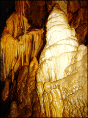
Slovakia also contains a number of interesting and unusual caves. Among them are the Demanovska caves, a series of caves linked by underground lakes and waterfalls, located in central Slovakia. The Domica cave, known for its vaulted roof and colored stalactites is located near the Hungarian border in eastern Slovakia. The Dobsinska Ice Cave is located in Low Tatras.
The Danube is Slovakia's main navigable river. Other important rivers include the Vah, Hron, Ipel, Nitra, Ondava, Laborec, and Hornad. Many smaller glacial lakes are located in the High Tatras, Strbske pleso is one of the most famous ones.
| Principal Cities |
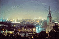
Bratislava, Slovakia's capital and largest city, has an estimated population of 450,000. Other important cities include the Eastern Slovak metropolis; Kosice (235,000), an industrial city; Nitra (90,000), a food-processing and agriculture center; Presov (90,000), and Banska Bystrica (85,000) in the center of Slovakia.
| Environmental Issues |
Citizen concerns about the environment particularly
air and water pollution increased in the 1990s.
However, efforts to shut down pollution-producing
industrial plants have been hampered by economic
considerations, including rising concern over Slovakia's
high unemployment rate. |

