 Geography Geography |
| Topography |
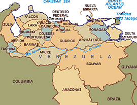
Most observers describe Venezuela in terms of four fairly well-defined regions: the Maracaibo lowlands in the northwest, the northern mountains extending in a broad east-west arc from the Colombian border along the Caribbean Sea, the wide Orinoco plains, llanos, in central Venezuela, and the highly dissected Guiana highlands in the southeast.
The Maracaibo lowlands form a large spoon-shaped oval bounded by mountains on three sides and open to the Caribbean on the north. The area is remarkably flat with only a gentle slope toward the center and away from the mountains that border the region. Lago de Maracaibo occupies much of the lower-lying territory. Areas around the southern part of Lago de Maracaibo are swampy, and, despite the rich agricultural land and significant petroleum deposits, the area was still thinly populated in 1990.

The mountains bordering the Caribbean Sea are actually the northeastern extension of the Andes chain. Broken by several gaps, these high mountains have peaks over 4,500 meters; the fertile valleys between the ranges contain most of Venezuela's population, industry, and agriculture. The discontinuous westernmost range runs along the Colombian border and is the least densely populated part of this region. The ranges southeast of Lago de Maracaibo contain some of the highest peaks in the country (Pico Bolívar reaches 5,007 meters), a few of which are snowcapped year-round.
A broad gap separates this mountainous area from another rugged pair of ranges that parallel the north-central coast. The series of valleys between these two parallel ranges constitutes the core area of the country; as the site of burgeoning metropolitan Caracas, this comparatively small area hosts the country's densest population, the most intensive agriculture, and the best transportation network. Another broad gap separates this area from the easternmost group of mountains, a series of dissected hills and uplands that rise steeply from the Caribbean and extend eastward almost to Trinidad.
The great expanse of lowlands known as the Orinoco plains extends westward from the Caribbean coast to the Colombian border between the northern mountains and the Río Orinoco. This region is commonly known as the llanos, although it also contains large stretches of swampland in the Orinoco Delta and near the Colombian border. The area slopes gradually away from the highland areas that surround it; elevations in the llanos never exceed 200 meters. North of the Río Apure, rivers flowing out of the northern mountains cut shallow valleys, leaving eroded ridges that give the land a gently rolling appearance. South of the Apure, the terrain is flatter and elevations lower.
| 
One of the oldest land forms in South America, the Guiana highlands rise almost immediately south and east of the Río Orinoco. Erosion has created unusual formations in this region. Comprising over half of the country, the highlands consist primarily of plateau areas scored by swiftly running tributaries of the Orinoco. The most conspicuous topographical feature of the region is the Gran Sabana, a large, deeply eroded high plateau that rises from surrounding areas in abrupt cliffs up to 800 meters high. Above the rolling surface of the Gran Sabana massive, flat-topped bluffs emerge; many of these bluffs (referred to as tepuis by the Venezuelans) reach considerable altitudes. The most famous tepui contains Angel Falls, the world's highest waterfall.
| Climate |
Although the country lies wholly within the tropics, its climate varies from tropical humid to alpine, depending on the elevation, topography, and the direction and intensity of prevailing winds. Seasonal variations are marked less by temperature than by rainfall. Most of the country has a distinct rainy season; the rainy period (May through November) is commonly referred to as winter and the remainder of the year as summer.
The country falls into four horizontal temperature zones based primarily on elevation. In the tropical zone--below 800 meters--temperatures are hot, with yearly averages ranging between 26° C and 28° C. The temperate zone ranges between 800 and 2,000 meters with averages from 12° C to 25° C; many of Venezuela's cities, including the capital, lie in this region. Colder conditions with temperatures from 9° C to 11° C are found in the cool zone between 2,000 and 3,000 meters. Pastureland and permanent snowfield with yearly averages below 8° C cover land above 3,000 in the high mountain areas known as the páramos.
Average yearly rainfall amounts in the lowlands and plains range from a semiarid 430 millimeters in the western part of the Caribbean coastal areas to around 1,000 millimeters in the Orinoco Delta. Rainfall in mountainous areas varies considerably; sheltered valleys receive little rain, but slopes exposed to the northeast trade winds experience heavy rainfall. Caracas averages 750 millimeters of precipitation annually, more than half of it falling from June through August. |

