 GEOGRAPHY GEOGRAPHY |
At independance, in 1960, the former Belgian Congo adopted the name Republic of the Congo. This name was changed since then several times going from Democratic Republic of Congo (DRC) to Zaire, but it has allways distinguished itself from its neighbor indicating the name of its capital city: Kinshasa.
Second largest country of sub-Saharan Africa, occupying some 2.344.885 square kilometres (almost the size of western Europe), DRC is bordered by 9 different countries; the Congo Brazzaville, the Central African Republic, the Sudan, Uganda, Rwanda, Burundi, Tanzania, Zambia and Angola. Most of the country lies within the vast hollow of the Congo River basin that has the shape of an amphitheater, open to the north and northwest and closed in the south and east by high plateaus and mountains.
Click on the map
to enlarge it (100 kb)
The edges of the basin are breached in the west by the passage of the Congo River to the Atlantic Ocean; they are broken and raised in the east by an upheavel of the Great Rift Valley (where lakes Mweru, Tanganyika, Kivu, Edward and Albert are found) and by overflow from volcanos in the Virginia mountains.
The Congo River
The Congo River (also known as the Zaire) is over 2,720 miles (4,375 km) long. It is the fifth longest river in the world, and the second longest in Africa, after the Nile River in Northeastern Africa. The Congo River flows primarily through the Democratic Republic of the Congo (DRC), the People's Republic of the Congo, the Central African Republic, and partially through Zambia, Angola, Cameroon, and Tanzania. The Congo ranges in width from 0.5 to 10 miles (0.8 to 16 km) depending on the location and time of year.
The Congo River forms in the southern most part of the DRC where the Lualaba and Luvua Rivers meet. The Congo then flows to Stanley Falls, near Kisangani, a point just north of the Equator before taking on a counterclockwise course. The Congo loops first to the northeast, then to the west, and then to the south before reaching an outlet into the Atlantic Ocean, feeding a river basin that covers over 1.6 million square miles (4.1 million sq. km). At the outlet into the Atlantic Ocean, the Congo can dispose of up to 1.2 million cubic feet (34,000 cu m) of water per second.
Over 4,000 islands can be found within the Congo's banks, more than 50 of which are at least 10 miles (16 km) in length. It is because of these islands that some stretches of the Congo are unnavigable. It has been estimated that almost 250 miles (400 km) of the Congo are unnavigable due to these islands plus a number of cataracts, in particular at Livingstone Falls.
Due to the fact that the Congo has many tributaries, the Congo River is the biggest transportation facility in Central Africa. The Ubangi River is a major tributary, along with the Aruwimi, Kasai, and Lomami Rivers. The Congo River and all the streams that contribute to it together account for over 9,000 miles (14,500 km) of navigable routes across Central Africa. | Other features:
Major geographic regions include central Congo River Basin, uplands north and south of basin, and eastern highlands. Core region is central Congo River Basin, large depression with average elevation of about forty four meters, constituting about one-third of DRC. In north and south of the basin lie higher plains and hills covered with mixtures of savanna grasses and woodlands. Southern upland region also constitutes about one-third of DRC, with elevations between 500 meters and 1,000 meters. Eastern highland region is the highest and most rugged portion, bounded by Great Rift Valley, some such as the Ruwenzoris approach the 5000 m mark. Eastern border extends through the valley and its system of lakes. Most of DRC is served by Congo River system. Congo River and its tributaries provide DRC with Africa's most extensive network of navigable waterways as well as vast hydroelectric potential. Flow of Congo River is unusually regular because tributaries feed in from both sides of equator.
Climate:
DRC lies on the Equator, with one-third of the country to the north and two-thirds to the south. The climate varies according to distance from the Equator; hot and humid in the river basin and cool and dry in the southern highlands. South of the Equator, the rainy season lasts from October to May and north of the Equator, from April to November. Along the Equator, rainfall is fairly regular throughout the year. During the wet season, thunderstorms are often violent but seldom last more than a few hours. The average rainfall for the entire country is about 107 centimeters (42 in.). The annual temperatures are warm.
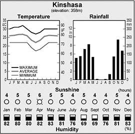
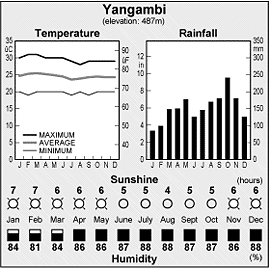
Required clothing:
Lightweight clothes are recommended all year, with rainwear during the rainy season.
See H. Winternitz, East Along the Equator: A Journey up the Congo and into Zaïre (1987).
|

