 GEOGRAPHY
& CLIMATE GEOGRAPHY
& CLIMATE |
Geography
Straddling the equator in western South America,
Ecuador has territories in both the Northern and
the Southern hemispheres. It borders Colombia
to the north and shares a border Peru to the south
and to the east. The Pacific Ocean is Ecuador's
western border. Despite Ecuador's size - about
equal to the North American state of Colorado
- it is one of the most geographically diverse
countries in the world.
Ecuador is comprised of four distinct geographical
regions (the Amazon, the Highlands, the Coast,
and the Galapagos Islands) and is politically
split into 22 provinces, which, in turn, are split
into 205 cantons. The coastal provinces (from
north to south) are Esmeraldas, Manabí,
Los Ríos, Guayas, and El Oro. Highlands
provinces are Imbabura, Pichincha, Cotopaxi, Tungurahua
and Chimborazo, in the north, and Bolívar,
Cañar, Azuay and Loja, in the south. The
Amazon is comprised of the provinces (from north
to south) of Sucumbíos, Napo, Pastaza,
Orellana, Morona-Santiago and Zamora-Chinchipe.
Ecuador's 22nd province is the Galapagos Islands.
Pacific Coast
Ecuador's coastal region (a.k.a. the western
lowlands) is made up of fertile plains, rolling
hills, and sedimentary basins traversed by a plethora
of rivers that rush from the heights of the Andes
to the Pacific Ocean. All five coastal provinces,
encompassing 640 kilometers of coastline between
them, have attractive beaches and plenty of hotels
and resorts for tourists. Crisscrossed by an expansive
network of rivers and home to the nation's most
spectacular beaches, the provinces of Esmeraldas,
Manabí, and Guayas quite impressive destinations
frequented by tourists from all over the world.
Geographically speaking, much of this area is
part of the Guayas River Basin, which has at least
twelve major tributaries located primarily near
the communities of Daule, Babahoyo, Macul, Puca,
Paján, and Colimes.
The Highlands - The Andes & the Austro
The Andes Mountain Range crosses the country from
north to south. The Occidental and the Oriental
Ranges are born from this mountain system as it
divides in the province of Loja, forming plains
and valleys along the Andean Corridor. Between
the two ranges there is a plateau which reaches
heights of three thousand meters.
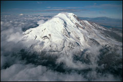
The Highlands Regions, commonly referred to as
La Sierra, is made up of ten provinces, each of
which have important peaks such as Chimborazo
(6,310 m.), the Illinizas (5,248 m.), Cotopaxi
(5,897 m.), Cayambe (5,790 m.), and Antisana (5,758
m.).
|
The highest peaks are
found in central and northern Ecuador. From Riobamba
towards the south there is a decrease in altitude
and an increase in the width of the mountain range,
forming a kind of plateau known as the Austro.
The Amazon Region
The Amazon Region and its five provinces can
be geographically divided into two sub regions:
the High Amazon and the Amazon Lowlands. The Highlands
is comprised of the Andean foothills which slowly
descend towards the Amazon River Basin. Here,
you'll find the Napo, Galeras, Cutucú,
and Cóndor ranges. The most impressive
elevated regions of this area are in the north
and include Volcano Sumaco. The Lowlands, found
further to east, are home to some of the nation's
most beautiful and important rivers: the Putumayo,
the Napo, and the Pastaza.

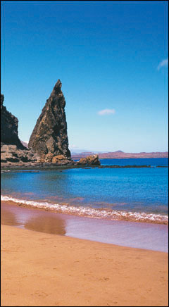
Galapagos
The Archipelago of Colón (commonly known
as the Galapagos Islands) is made up of 13 main
islands, 17 islets, and dozens of ancient rock
formations. The volcanically formed islands, encompassing
an area of 8,000 kilometers in all, lies roughly
1,000 kilometers off the coast of the Ecuadorian
mainland. Apart from its beautiful beaches and
unique and varied ecosystems, the Galapagos Islands
are home to towering active volcanoes that reach
altitudes up to 1,600 meters.
| Climate |
Due to geographic differences in altitude, longitude
and latitude, and the climatic effects of the
Pacific Ocean, the Amazon, and the Andes, the
various regions and sub regions of Ecuador have
very different climates and microclimates.
The Pacific coast has a rainy season between December
and May and a dry one from June to November. It
has an average temperature of 25ºC (76 F).
The Highlands, on the other hand, has a rainy,
cold climate from November to April and a dry
one from May to October. The temperature here
varies according to the altitude; at a higher
altitude it is colder. The average temperature
is 15ºC (64 F).
In the Amazon, the climate is rainy and humid
between January and September, and it is dry between
October and December. The average temperature
is 26ºC (80F).
The Galapagos Islands have a dry and warm pleasant
weather. The average yearly temperature is 28º
C. (85 F).
|

