 GEOGRAPHY GEOGRAPHY |
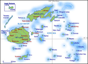
The Fiji islands are located to the southwest of
the Pacific Ocean, north of the tropic of Capricorn
and south of the equator. Australia is 3,160km to
the southwest, and New Zealand lies 2,120 km to
the south. Nearby Pacific State Islands include
Tonga to the east and Vanuatu to the west.
Fiji's territorial limits cover an area of over
1.3 million sq km, but less than 1.5% of this
is dry land. The total land area is about 18,300
sq km. The Fiji islands lie between latitudes
12º and 21º south of the equator, and
between longitudes 177º east and 175º
west. The 180º meridian cuts across the group
at Taveuni, but the International Date Line doglegs
eastward so all islands fall within the same time
zone - 12 hours ahead of Greenwich Mean Time.
Click
to enlarge
The archipelago includes more than 300 islands.
Island dimensions differ from tiny plots of land
a few meters in width to Viti Levu, or 'big Fiji',
which is 10,390 sq km. The second largest island
is Vanua Levu, or 'big land', with an area of
5,538 sq km. Only about one-third of the islands
are inhabited, mainly due to remoteness and to
lack of fresh water.
The highest peak in Fiji is in Viti Levu, Mt Tomanivi,
or Mt. Victoria, at 1,323m. It is near the northern
end of the diving range that separates east from
west. Suva, the country's capital, is in the south
east of Viti Levu.
Both Nadi, home to the country's main International
airport, and Lautoka the second most important
port after Suva, are on the western side of Viti
Levu. In 'big Fiji' you find also the country's
largest rivers. Viti Levu is the island where
the most extensive transport system is. The Kings
Road and the Queens Road connect together to form
a main road that goes around the island's perimeter.
Northeast of Viti Levu you find Vanua Levu a jagged
contour island with many bays of various shapes
and sizes. The enormous, as compared to any other
in Fiji, Natewa Bay is about 70 km long and 15 km
wide. Like Viti Levu, the main part of the island
is divided by a mountain range. Nasorolevu (1,032m)
is the highest peak. Most roads are unsealed, but
a sealed stretch links the two main towns: Savusavu,
in the south, and Labasa, in the north.
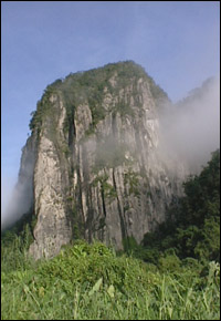
The Somosomo Channel separates Taveuni, the third
largest island, from Vanua Levu. It is rugged
with rich volcanic soil and flourishing plant
life. It is what they call ´Fiji garden
island´. Its mountainous backbone of volcanic
cones includes Uluigalau (1,241m), the second-highest
summit in Fiji.
The Kadavu Group is South of Viti Levu. It includes
Kadavu, of similar size to Taveuni, Ono and a
large number of small islands, all within the
Astrolabe Reef. The main island is three irregularly
shaped, rugged landmasses linked by isthmuses.
Like Taveuni, Kadavu is very picturesque, with
beautiful reef lagoons, mountains, waterfalls
and opaque vegetation.
The rest of Fiji's island are fairly small and
are catalogued in groups: Lomaiviti, Lau, Moala,
Yasawa, Mamanuca and Rotuma. Beqa, Yanuca and
Vatulele are gorgeous small islands off southern
Viti Levu.
|
| FLORA AND
FAUNA |
Fiji's flora and fauna are moderately few in number
but are of outstanding scientific curiosity because
of the higher amount of endemic forms - i.e. those
found anywhere else in the world. 10% of the 475
indigenous Fijian plant species known are endemic.
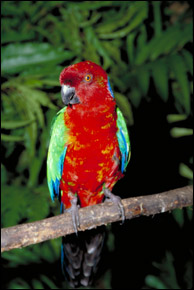
Fiji also has a few rare reptiles and birds. Notable
of this, is the Crested Iguana, found only in
some parts of Fiji namely Yadua Taba in Bua and
the Yasawas. Other exceptional species include
the Fiji burrowing snake, Fiji petrel, the pink-billed
parrot finch, the red throat lorikeet and the
long legged warbler.
Recently two reporters in conjunction with the
Fiji Museum found bones of crocodile, giant tortoises
and giant Fiji pigeons during one of their projects.
The crocodiles were around two and a half meters
long and the giant iguanas a meter and a half
long. The bones of these long extinct animals
were found in the Volivoli and Qarinivokai caves
which is situated to the West of Sigatoka dunes.
| TYPES OF
ISLAND AND CORAL REEFS |
Volcanic Islands
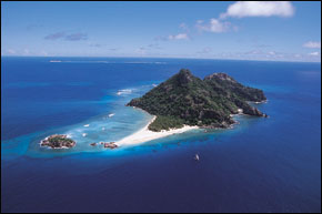
These are usually of high relief with a series
of conical hills rising to a central peak. Spiky
summits point out the locations of old volcanoes
and crystallized magma runs frequently arrive
at the coast to form rock faces. Between these
ridges are green valleys, and on the coast are
beaches and mangrove communities. Flat land is
only found in the river valley of the larger islands.
The sides of the island facing the prevailing
winds get more rain and support thriving perennial
forest vegetation. The leeward hills are home
to grasslands with only a sparse covering of trees.
While there are no active volcanoes in Fiji, live
volcanic vents have been discovered on Taveuni.
There is plenty of geothermal activity on Vanua
Levu, and in Savusavu some local use their hot
spring to do their cooking! Viti Levu and Kadavu
are also volcanic islands.
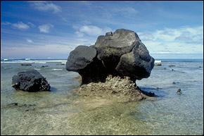
Limestone islands
These are characteristically rocky landmasses
that have uplifted from the sea. They have cliffs
by the sea, with bushes and trees growing on the
top. Generally, there is a central depression
forming a basin, with fertile surging hills. Volcanic
material also thrust up through the limestone
mass.
Coral Islands
These are small low islands without many topographic
variations. In general, they are situated in areas
sheltered by barrier reef. Surface echelons rise
only to the height at which waves and winds can
deposit sand and coral fragments. These islands
support plain yet abundant vegetation, mostly overhanging
palms, broad-leafed trees, shrubs, vine and grasses.
The coast has bright, white sand beaches and mangroves
in the shallows of lagoons. Examples of coral islands
are Beachcomber Island and Treasure Island, in the
Mamanuca Group, and Leleuvia and Caqeli in the Lomaiviti.
Fringing Reefs
These are usually narrow stretches of reef linked
to the shore and extending seaward. Sometimes
they can extend up to 5km out from the shore.
During low tide the reefs are exposed. Often the
bigger fringing reefs have higher sections at
the open sea edge and drainage. Rivers and streams
break the reefs, the fresh water preventing coral
growth. The Coral Coast on southern Viti Levu,
is an example fringing reef. Most islands in Fiji
have sections of fringing reefs somewhere along
their coast.
Barrier Reefs
These are strips of continuous reef, broken only
by occasional channels some distance from the
coastline. They sometimes encircle islands and
often occur in combination with fringing reef.
The biggest barrier reef in Fiji is the Great
Sea Reef, which extends 500 km from the coast
of southern-western Viti Levu to the northern
most point of Vanua Levu. A section of this barrier
is unbroken more than 150 km, and lies between
15 and 30 km off the coast of Vanua Levu. Other
smaller barrier reefs include the one encircling
Beqa Lagoon, and the Astrolabe Reef of Kadavu.
Atolls
These are small islands rising just above the
sea level, sitting on a ring of coral reef a lagoon.
An atoll where the land forms a complete circle
is rare, and is invariably small when it does
occur. Despite the idyllic representation of atolls
in tales of the South Pacific, most have inhospitable
environments. The porous soil derived from dead
coral, sand and driftwood retains little water
and unless the atoll is situated within a rain
belt it is subjects to droughts. The vegetation
is usually small and hardy, with species such
as pandanus and coconut palms, shrubs and coarse
grasses. Fiji has only a few islands that can
be classified as atolls. The most well known is
Wailagi Lala, east of Nanuku Passage in the Lau
Group. There are, however, a number of 'looping'
barrier reefs that encircle island.
|


