 Geography Geography
|
The 9th Biggest country of the World.
Kazakhstan is a vast country covering more than
2.7 million sq km with a population of almost
15 million people.
Borders:
The country spans over 2,600km from its western
border with Russia to its eastern flank on the
Chinese border. Though only covering one-sixth
the area of Russia, Kazakhstan exceeds the territory
occupied by twelve countries of the European Union,
and is among the tenth largest states in the world.
The territory of the Republic stretches from the
low reaches of the Volga in the West to
the foothills of the Altai mountains in
the East, from West Siberian lowland in
the North to the desert of Kyzylkum and
the mountain range of Tian Shan in the
South.
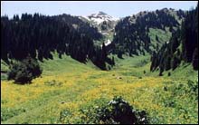
Extensive rolling plains cover most of its surface,
rising in the south-east towards the Central Asian
massif and the mountain ranges of the Altai and
Tian Shan.
Kazakhstan borders on the Russian Federation (6,467
km) to the north and west, the Caspian Sea (1,450
km), Turkmenistan (380 km) and Uzbekistan (2300
km) to the southwest, Kyrgyzstan (980 km) to the
south and China (1,460 km) to the southeast.
Regional differences:
There are distinct regional differences, distinguishing
the country's terrain.
The western part of the country is almost
exclusively plain-like
The eastern one is predominantly mountainous.
The continental position of Kazakhstan in the center
of the Eurasian continent is its distinctive feature,
and is reflected in the entire physical and geographical
make-up of the territory, its hydro-geography, and
its plant and animal life.
There is considerable topographical variation within
Kazakhstan:
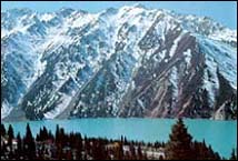
The highest elevation is Khan Tengri Mountain on the Kyrgyz border in the Tian Shan range, is 6,995 meters
The lowest point is Karagiye in the Caspian Depression
in the west, is 132 meters below sea level.
Only 12.4 percent
of Kazakhstan is mountainous, with most of the
mountains located in the Altay and Tian Shan ranges
of the east and northeast, although the Ural Mountains
extend southward from Russia into the northern part
of west-central Kazakhstan. Many of the peaks of
the Altay and Tian Shan ranges are snow covered
year-round, and their run-off is the source for
most of Kazakhstan's rivers and streams.
 |
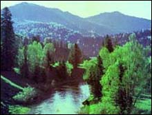
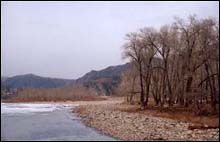
Kazakhstan's
East and Southeast possess extensive watercourses:
most of the country's 7,000 streams form part of
the inland drainage systems of the Aral and Caspian
seas and Lakes Balkhash and Tengiz. The major exceptions
are the great Irtysh, Ishim (Esil), and Tobol rivers,
which run northwest from the highlands in the southeast
and, crossing Russia, ultimately drain into Arctic
waters. In the west the major stream, the Ural River,
flows into the Caspian Sea. In the south the waters
of the once-mighty Syr Darya have, since the late
1970s, scarcely reached the Aral Sea at all. The
Caspian Sea, the largest inland body of water
in the world, forms Kazakhstan's border for 1,450
miles of its coastline. Other large bodies of water,
all in the eastern half of the country, include
Lakes Balkhash, Zaysan, Alakol, Tengiz, and Seletytengiz
(Siletiteniz). Kazakhstan also wraps around the
entire northern half of the shrinking Aral Sea,
which underwent terrible decline during the second
half of the 20th century: as freshwater inflow was
diverted for agriculture, the salinity of the sea
increased sharply, and the receding shores became
the source of salty dust and polluted deposits that
ruined the surrounding lands for animal, plant,
or human use.
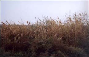
Some 9.4 percent of Kazakhstan's land is mixed
prairie and forest or treeless prairie, primarily
in the north or in the basin of the Ural River in
the west. More than three-quarters of the country,
including the entire west and most of the south,
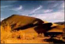
is either semi-desert (33.2 percent) or desert (44
percent). The terrain in these regions is bare,
eroded, broken uplands, with sand dunes in the Kyzylkum
("red sand") and Moin Kum deserts, which
occupy south-central Kazakhstan. Most of the country
lies at between 200 and 300 meters above sea level,
but Kazakhstan's Caspian shore includes some of
the lowest elevations on Earth.
Very fertile soils characterize the lands
from far northern Kazakhstan down to the more infertile,
alkaline soils of the middle and southern areas.
The vast stretches of arable land in the northern
plains are the most intensely cultivated and productive.
Other cultivated areas fringe the mountains in the
south and east; irrigation and reclamation, when
feasible, extend along river valleys into the deserts.
Nuclear bomb testing conducted during the Soviet
period near Semey (Semipalatinsk) contaminated the
soils in the vicinity.
Climate:
The climate in Kazakhstan is a continental
one. The most of its territory is covered with semiarid
steppes which in the north change into forest-steppe
and in the south to semi-deserts and deserts.
To the east and southeast, Kazakhstan is bounded
with the edges of the Altai and Tian Shan mountains
which moderate the temperature and humidity. In
the north, the average temperature in summer reaches
18C (64.4F), and 30C (86F) in the south. In January
it varies from minus 20C (-4F) in the north to minus
1C (30.2F) in the south. Around Almaty, winter temperatures
are 2C (35.6F) to minus 20C (-4 F) and in summer
20C (68F) TO 38C (104F). The best seasons to visit
are late spring and early summer.
 |

