 GEOGRAPHY GEOGRAPHY |
Landlocked Kyrgyzstan is slightly larger than Austria
and Hungary put together. Kyrgyzstan has an area
of approximate 199.000 square kilometers (74.64
square miles), the altitude ranges from 401 meters
in the Fergana valley to 7.437 meters at the Peak
Pobeda. Nearly 95% of the country is mountainous:
almost half of it at an elevation of over 3000m
(9840ft) and three-quarters of it under permanent
snow and glaciers. 4.3 % of the land is covered
by snow and forest makes up 5.1%. The main natural
resources are antimony, gold, coal, lead, mercury
and uranium. Kyrgyzstan is located on north-east
of Central Asia and borders Kazakhstan in the north,
China in the east, Tajikistan in the south and Uzbekistan
in the west.
Tien-Shan Shan range in the south-east (Mountains
of Heaven) is a dominant topographic feature of
Kyrgyzstan. Its crest, the dramatic Kakshaal-Too
range, forms a stunning natural border with China,
culminating at Pik Pobedy (7439m/24,400ft), Kyrgyzstan's
highest point. The southern border with Tajikistan
lies along the Pamir Alay Range. Lake Issyk-kul,
almost 700m (2300ft) deep, is surrounded by the
Terskei and Kungey Alatau from north and south correspondingly;
the south side of the Chuy Valley is mounted by
Kyrgyz Alatau; Fergana range forms the eastern wall
of the Fergana and Chatkal range forms the northern
wall of valley.
There are 1923 lakes in Kyrgyzstan, lake Issyk-kul
is one of the deepest mountain lakes in the world,
and it derives its glory from its sky blue colour,
high mineral content and the fact that it never
freezes.
The Naryn river rises in the At-Bashy range and
joins the Kara Darya in the Fergana Valley to become
the Syr Darya. There are seven power stations located
on Naryn river. The Chuy river is channelled into
a major irrigation canal along the Kazakh border.
The Sary Jas, Inylchek and Ak-shyrak rivers flow
east to China's Tarism basin.
| CLIMATE
|
The weather in May be changeable but is usually
mild-warm; June is warm-hot; July-August is very
hot and sometimes unpleasant (38-40 degrees most
days peaking at 50 degrees in Bishkek in 1998),
though usually not very humid; in September warm-hot;
in October cool and possibly cold towards the
end of the month. Snow usually arrives mid-November
but does not lie long on the ground. Snow will
be intermittent between November-March, and possibly
even earlier or later. It usually melts between
falls. December and January are the coldest months
and most days will be below freezing. By the end
of February temperatures become changeable but
are warming; March and April can be very changeable
and wet.
Bishkek enjoys a very sunny climate on the whole:
there is sunshine on over 300 days per year (though
it is not sunny, necessarily, for the whole of
every day.) Note: in 1998 and 1999 there was unusually
wet weather in May, June and even July - still
warm, with lots of sunshine but often rain especially
in the evenings. The year 2000 to date has been
very warm: June had the hottest day (for June)
ever recorded. July 2000 and 2001 were also exceptionally
hot even from the start of the month. July 2001
saw exceptionally heavy rainfall more than the
monthly falling on one day.
|
In the mountains, the
weather resembles that of Bishkek but is more extreme:
nights will be much cooler, even in mid-summer.
Night temperatures of -30C or lower are not uncommon
in winter - even worse in Naryn or Sussamir (whereas
in Bishkek, -15C would be considered very cold.)
In Lake Issyk Kul summer days may be hot but it
is never hot at night and may be cool at night even
in high summer. Winters are very cold, despite the
name "warm lake". In fact, the lake is
never very warm for bathing (but is quite tolerable
in summer): the name simply indicates that it never
freezes over. The water is slightly salty and thought
to be very good for the skin.
On the high passes such as Torugart, snow may fall
occasionally even in the height of summer, (In the
last three years bad weather has closed the Torugart
pass for three to five days in July and August).
Four climate zones are determined here:
Valley zone (from 500-600 to 900-1000m heights).
Hot summer (to +28 degrees) and moderate cold and
snow less winter characterise it. Average annual
temperature is +20-25 in summer and -4 -7 in winter.
In some places temperature reaches +47. It drops
as the height increases and the absolute temperature
minimum is -22-30,only in some places it drops lower
-40.
Middle mountainous zone (from 900-1200 to
2000-2200 m heights) has typical moderate climate
with warm summer and moderate snowy and cold winter.
Average annual temperature is +18-19 in summer (July)
and -7-8 in winter (January).
High mountainous zone (from 2000-2200 to
3000-3500 m heights) is characterised by cold summer
and very snowy winter. July temperature is +11-16,
January - 8-10. Winter is long (from November to
March). In the upper part of this zone the freezing
period lasts 3-4 months.
| ENVIRONMENT |
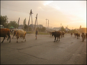
Kyrgyzstan is a special land as despite its small
size it has a large variety of plants and animals,
possessing nearly 1% of all known species in just
0.13% of the world's land mass. It is particularly
rich in medicinal herbs. Kyrgyzstan's ecology is
fragile and much depends on the specific combination
of species which appeared here and which play an
important role in such processes like recreation
and preservation of soils, water distribution, cleaning
of surface waters, and atmospheric composition.
Though environmental pressures are as bad in Central
Asia as anywhere, there's a reasonably good chance
of seeing memorable beasts and plants, especially
since Cannabis indica grows thick and wild by the
roadsides. The mountains of Kyrgyzstan are the setting
for high, grassy meadows - it's not unheard of to
look out a train or bus window on the open steppe
and see a rushing herd of antelope. Marmots and
pikas are preyed upon by eagles and lammergeiers
while the elusive snow leopard hunts the ibex amongst
the crags and rocky slopes. Forests of Tian Shan
spruce, larch and juniper provide cover for lynx,
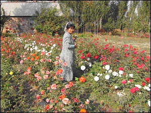
wolf, wild boar and brown bear. In summer, the wildflowers
are a riot of colour. Nature is important to Kyrgyz
culture; handicraft designs take inspiration from
the patterns of the natural world, while folklore
and music rely heavily on a spiritual association
with nature, reflecting the Kyrgyz's nomadic roots.
The climate of this mountainous region is influenced
by its distance from the sea and the sharp change
of elevation from neighbouring plains. Conditions
vary from permanent snow in high-altitude cold deserts
to hot deserts in the lowlands. From the end of
June through mid-August most afternoons reach 32°C
(90°F) or higher, with an average annual maximum
of 40°C (104°F). During the winter months,
temperatures remain below freezing for about 40
days. The coldest month is January when winds blow
in from Siberia. |

