 Regional
Map & Climate Regional
Map & Climate |
Primorsky Krai: Situated in the Far East of Russia.
Area: 168 000 km2
Population: Approximately 2 300 000 people,
Territory Range: 900 km from the North to the South
and 600 km from the West to the East.
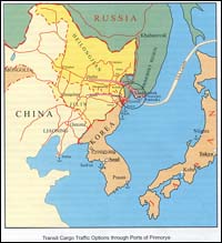
Vladivostok, also referred to as the "Lord
of the East" in Russian is located less than
100 km east of the Chinese border, and just across
the Sea of Japan from the main Japanese island of
Honshu. Home base of the Russian Pacific Fleet,
the city was closed to all non-Soviets from 1958
until 1991.
Between its founding in 1860 and closed period to
foreigners in 1958, Vladivostok was a fairly international
city. In the early part of the 20th century, Russians
were actually outnumbered by Chinese in Vladivostok,
and during the years following the Revolution, there
were large Japanese and US populations.
Vladivostok became Russia's main naval base in the
East after Port Arthur (located in Chinese territory
and ceded to Russia in 1898) fell in January 1905,
during the Russo-Japanese war. Modern Vladivostok
has been compared to the American West during the
Gold Rush years. Businesses from all over the world
have flooded in to take advantage of the city's
position as a crossroads of Northeast Asia.
|
Climate
|
Primorsky Krai is located in the southeast part
of Russia, on the west coast of the Sea of Japan.
The climate within the region is continually influenced
by both continental and sea climate conditions.

Being situated on border of the biggest in the
world continent and greatest of oceans (Pacific
ocean), Primorsky Krai constantly experiences
influence of these two giants on itself. Crucial
importance has not so much the arrangement of
Krai in rather low latitude of a moderate zone,
as its position at edge of huge continent Asia,
which is strongly cooled on winter and warmed
up on summer.
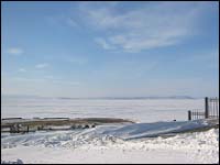
Weather in Primorsky Krai is determined by monsoons.
In the winter the territory of region is under
prevailing influence of very cold and dry air
mass, which formed in the field of a powerful
Asian anticyclone. The resulting stream of air
is directed from areas of China to a southeast,
from area of the Asian anticyclone to area of
lower pressure, which is situated over Pacific
Ocean and purlieu seas.
The weather during the winter is under influence
of a VERY cold and dry wind. So you can expect
temperatures from -20°C to -25°C in Vladivostok
and temperatures that can reach more then -35°C
when you travel to the North. So during winter
months if you decide to spend long periods of
time outdoors the only one advice is to be well
prepared. Bring with you a good winter coat, thermal
underwear, warm socks, plenty of moisturiser,
gloves and a hat, Russians traditionally wear
a Shapka, which is a hat made of animal fur and
acts as a great heat insulator for your head.
Absolute
In spring and summer temperatures can increase
to a maximum of 25°C on the seacoast. During
this period from June until the beginning of August
you may enjoy the pleasure of the beaches!! But
still do not forget that you are in the Far East
and that the climate can change quickly. The level
of precipitation in spring and summer can be high.
Don' forget to bring with you a raincoat, an umbrella
and of course a swimming suit in case of!!!!
|

Table
In summertime movement of air mass gets an opposite
direction. At this time by southeast winds are
brought relatively cool and damp sea air in first
half of summer and very damp and warm - in its
second half.
Duration of the cold period at the most part of
region is 130 - 160 days, and only in northern
part of the western foothills and at tops of Sikhote
Alin it is increased to 180 days.
.
Spring is long in Primorsky Krai. At spring in
continental areas the rising of air temperature
from 0 to 10 occurs for 30 - 45 days, at the coast
of Japanese sea and at the coastal areas this
period is increased to 50 - 70 days.
The absolute minimum of air temperature, i.e.
temperature possible only in some night of the
coldest years is changed from 20 - 25°C (in
mountains 32 - 37°C of frost) in March to
4 - 9 °C below zero, in the south 0 - 2°C
heat in May. The highest values (an absolute maximum)
make in March - 16 - 21°C, in April - 25 -
30°C and in May - 30 - 35 °C. In first
half of April it is observed coming off a snow
cover. In the spring precipitation in comparison
with the winter period are increased to 30 - 60
mm, in May on some meteorological stations to
70 - 94 mm. In some years the droughty periods
are observed when the monthly sum of precipitation
does not exceed half of average long-term norm.
So, in 1989, 1993, 1997, 1998 precipitation on
the most part of continental areas was only 20
- 50 % from long-term norm.

Summer in Primorski Krai in the first half usually
hot and dry in a continental part and cool with
often fogs and a drizzle - at coast and in second
half - hot, damp, with plentiful rains. The average
monthly temperature of air in June is higher then
in May on 3 - 5°C on the coast of Japanese
sea. On eastern Sikhote Alin`s slopes and at all
coast of Sea of Japan it is 9 - 15°C. Moving
away from the coast deep into continent, the temperature
appreciably raises, and the greatest values of
average monthly temperature is marked in a valley
of the Arsenievka river and in average watercourse
of Ussuri - 16 - 18°C.
Variability of average monthly air temperature
from year to year is insignificant. In the first
decade of June in east areas the termination of
last frosts is marked. The temperature of air
in coldest night of June decreases to 0 - 3°C
in a flat part and in the south of region to 5
- 7°C heat. The value of absolute maximum
is 34 - 36°C, in coastal areas 27 - 30°C.
The amount of atmospheric precipitation is increased
by June and their distribution on the territory
non-uniform: the least on Prikhankajskaya plain,
the greatest - in Bikin, Big Ussurka, the Malinovka
rivers basin on the average a watercourse of Ussuri.
In these summer months among the dangerous hydrometeorological
phenomena very strong rain (amount of precipitation
is 50 mm and more, for 12 hours and less) and
long strong rains with amount of precipitation
100 - 120 mm and more for 2 - 3 days is marked.
In the summer the temperature of air raises from
a shore deep into territories, and its highest
values are observed on Prikhankajskaja plain (20
- 22). On the western slopes of Sikhote Alin its
value on 3 - 3,5°C higher than on eastern
slopes and at coast of Sea of Japan. The territory
of Primorski Krai concerns to a zone of sufficient
humidifying: about 80 - 92 % of precipitation
is related to the warm period of year, and the
bulk of plentiful falls and showers drops out
in second half of summer.

In November basically the firm and mixed precipitation
(50 - 80 %) prevail the share of liquid precipitation
make 20 - 50 %. The number of especially dangerous
snowfalls giving amount of precipitation 20 mm
and more for 12 hours appreciably grows.In November
formation of a steady snow cover is marked, except
the western and southern areas Prihankajskoj plain
and coast of sea of Japan. The average height
of a snow cover by the third decade of November
in the western foothills Sihote-Alinja reaches
8 - 15 mm.
|

