www.ebizguides.com
20
General Information
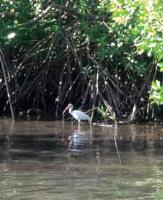
Rivers and Lakes
The main river is the Lempa, which is partially
navigable along the Torola River, its main tributary.
The length of the main flow is 422 kilometers, with
360.2 kilometers running through Salvadoran territory.
Some of the other rivers that run through El Salvador
are the Grande of San Miguel and Goascorán.
Treat nature well
Ilopango lake, close to San Salvador (Mitur)
Among the many existing lakes and lagoons the
most important are Lake Suchitlán, Coatepeque and
Olomega, Ilopango Lake and the lagoon of Alegría
in Usulután.
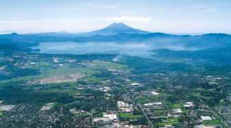
Weather
El Salvador is located in a tropical weather zone and
its climate is very consistent throughout the year.
However, due to the coastal strip along the Pacific
Ocean, important yearly oscillations occur, related to
ocean breeze, humidity and heat.
The annual average temperature (estimated period
1950-1990) is 24.8°C with the lowest average
temperature being in December (23.8°C) and
January (23.9°C). The hottest month is April (32°C).
The average annual precipitation is 1823 mm.
Since the thermometers of the Meteorological
Stations are influenced by the heat isle of the cities,
temperature has risen 1.2°C in the last thirty years.
The decade of the 80’s was one of the hottest (even
although, the statistic does not cover a century) with
precipitations influenced by the ENOS event.
El Salvador has two seasons: dry (November-April)
and rainy (May-October).
In addition, El Salvador is influenced by the
Caribbean hurricane season (June-November)
with frequent tropical storms and hurricanes that
increase the local river flows and affect some areas
with floods.