GEOGRAPHY GEOGRAPHY |

| The country |
 Name Name |
There are quite a number of explanations about how and where The Gambia sourced its name. The most plausible of the explanations however is that 'Gambia' is an evolved form of "Cambio", the term used by 16th century Portuguese traders and explorers to describe the river around which the country is built. La Cambio or exchange in lusophone was apparently an excited exclamation of the Portuguese traders for whom the river Gambia provided an excellent means of exchanging their goods with the market hinterland.
see map
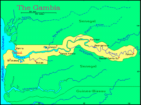
The Gambia is the smallest country on the African continent with a total area of about 11,000square kilometersof which 1,300 represents water area. Situated between latitudes 13 degree 45 W and 16 degree 50W on the Atlantic coast at the bulge of Africa, it is bounded on the West byabout 80 km coastline of the Atlantic Ocean and on all other sides by the republic of Senegal. The country forms a narrow stretch of land from the coast to about 400 kilometers inland, varying in width from about 50 kilometers near the coast to less than 35 kilometers island. The River Gambia is by far the most important geographical feature and it divides the country into two equal parts. It provides excellent river transport and is rich in fish resources, both marine and fresh water fishes. Banjul, the capital city is on the south with Bara a town significant in the relics of slave trade, on the north. The country lies within the Sahel, the semi-desert or Savannah region which forms a broad band across Africa between the Sahara Desert to the north and the forested countries of the south. The Gambia has a very flat landscape; it has not many hills or mountains, or any other very significant topographical feature. The lowest point, the Atlantic Ocean is at O m while the highest point, probably Jahally in the country's Upper River Division (URD) is only 53 m high. The Gambia River flows in an almost evenly flat landscape dropping less than 10 m in its entire 450 km stretch between its westernmost Banjul and Eastern end of Fatoto.
| The River |
A major attraction for the visitor to The Gambia, this great West African River rises in the Futa Jallon highlands nearly a thousand river miles away in the Republic of Guinea.
|
It crosses Eastern Senegal before entering Gambian territory some 300 miles (480 Kilometers) inland. In The Gambia, The River is the dominating feature and provides both a useful means of transportation and irrigation as well as a rich ground for fishing, boating and sailing.
The River Gambia is several miles wide at its mouth near Cape St. Mary and has a bar with a depth of 27 feet (8. 1 Meters). It narrows to three miles (4.8 Kilometers) at Banjul where the ferry to Barra operates. Ocean-going vessels up to about 3,000 gross registered (241 Kilometers) to Kuntaur. The River is also navigable to steamers for 140 miles (225 Kilometers) farther upstream.
For the first 80-Miles (129 kilometers) inland from Banjul, The River Gambia is fringed with mangrove-covered banks, which give way to red ironstone cliffs crowned with a tangle of green vegetation. Farther up River, the ironstone cliffs give way to banks of waving grass and parklands. The whole River and the numerous creeks (locally known as 'Bolons'), which join it, are fascinating to the bird lover and the student of nature: Hippopotami, Crocodiles and Dog-faced baboons are often seen.
In the past, The River's fame lay in the fact that, for sailing vessels, it was navigable at least as far as the country's eastern boundary; it is one of the finest waterways in West Africa. More recently, it has become the target for government development plans including an extension to the Port of Banjul. Fisheries development, Hydrological Surveys, a rice development project and even a feasibility survey for a bridge-barrage building program at the Trans-Gambia Ferry crossing near Farafenni. The Bridge-Barrage Project is to be a joint venture by the Senegalese and Gambian Governments.
In addition to Ferries, ships and cutters loaded with groundnuts, the country's main export crop, can be seen plying up and down the River, and dugout canoes used by fishermen are also a common sight, Their existence-, however, does not diminish the serene, tranquil beauty of the Great River flowing majestically westward into the Atlantic Ocean. Like their forerunners, the men-of-war and the slave ships, which fought battles and went this way in years, these river craft only add to the Gambia's colorful beauty.
| Other Features |
The country is mostly a low Plateau, which decreases in height as it nears the Atlantic Coast. The Plain is broken in a few places by low flat-topped hills and The River Gambia and its tributaries. The area extending from MacCarthy Island, where Georgetown is located, to the Eastern end of the country is enclosed by low Rocky Hills which appear to be volcanic. The soil, especially in the Kuntaur District, is clay along the Banks of The River, but elsewhere are alluvial soils, red, brown and gray sands, some gravel and isolated ironstone rocks. The Coast and River Banks consist largely of Mangrove swamps, and the lower part of the River has steep banks, which are covered with tropical forest, Bamboo being characteristic. Away from the River, there is wooded grassland, for the Gambia is in the Savannah Region of West Africa.
The country's narrow width and the large River that drains it have, however, given it more of a parkland look, with large areas covered by a variety of trees such as Mahogany, Rosewood, Oil Palm and Rubber. The Forestry Division of the Ministry of Agriculture, in addition to carrying out conservation measures, also does a brisk trade in local woods. |