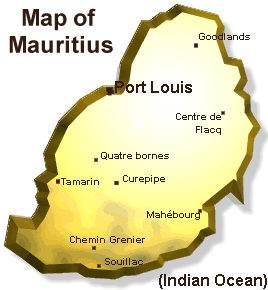
 Geography Geography |

Land area: 1,865 sq km
Population: 1.1 million
Capital city: Port Louis
Currency: Mauritian Rupee (Rs). 1US$ = MRs 24 (1997)
GDP: US$ 3,9 billion (1997)
GDP per capita: US$ 3,600 (1996)
GDP growth: 7% (1980-1990) ; 6% (1990-1997)
Composition of GDP:
Manufacturing: 21%
Services including tourism: 15%
Agriculture: 8%
Budget deficit: 4.6% (1995/96)
Inflation: 5.4 % (1997)
Productivity growth: 5% per year (1995/97)
|
Mauritius an island covering 1865 square kilometers is situated some
2000 kilometers off the south east coast of Africa. More than 150 kilometers of white
sandy beaches and transparent lagoon are protected from the open sea by the world’s
third largest coral reef which almost surrounds the island. Being of volcanic origin,
Mauritius has a central plateau which is about 400 meters above sea level. Mountains
scattered throughout the island, fast flowing rivers, tropical forests and plants, are
other features that add to the natural beauty of the island.
 Climate Climate |
Mauritius enjoys maritim sub-tropical climate.The summer season lasts
from October to May with temperatures averaging 27ºC, while in the winter months
temperatures average 22ºC. The topography of Mauritius makes the central plateau
more humid and cooler than the other regions. |

